- Redcar and Cleveland
-
Borough of Redcar and Cleveland 
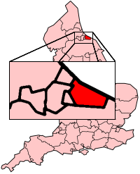
Status Unitary Authority, Borough Region North East England Zerem. Grafschaft North Yorkshire Trad. Grafschaft Yorkshire Verwaltungssitz Redcar Fläche 244,88 km² (174.) Einwohner 139.400 (129.) ONS-Code 00EE Website www.redcar-cleveland.gov.uk Das Borough of Redcar and Cleveland ist eine selbständige Verwaltungseinheit (Unitary Authority) an der Nordostküste Englands. Das zum Borough gehörige Gebiet war früher ein Teil der traditionellen Grafschaft Yorkshire. 1974 wurde es zu einem Distrikt der neugebildeten Grafschaft Cleveland und hieß Lambaurgh (nach einem der früheren Bezirke (wapentakes) von Yorkshire). Nachdem die Grafschaft Cleveland 1996 aufgelöst wurde, erhielt Redcar and Cleveland seinen jetzigen Namen und den Status eines Unitary Authority, die verwaltungstechnisch selbständig ist. Zu zeremoniellen Anlässen gehört Redcar and Cleveland zur Grafschaft North Yorkshire.
Zum Borough gehören die Orte Guisborough, Loftus, Redcar, Marske-by-the-Sea und Saltburn-by-the-Sea.
Redcar and Cleveland unterhält eine Städtepartnerschaft mit Troisdorf (Nordrhein-Westfalen).
2007 haben Archäologen bedeutende Ausgrabungen gemacht. Unter anderem wurden reich ausgestattete Grabanlagen entdeckt. Zum Beispiel das Grab einer unbekannten Prinzessin aus vorchristlicher Zeit.[1]
Anmerkungen
Weblinks
 Commons: Redcar and Cleveland – Sammlung von Bildern, Videos und Audiodateien
 Verwaltungsgrafschaften und Unitary Authorities in England
Grafschaften Englands mit zweistufiger Verwaltung (Non-Metropolitan Counties)
Buckinghamshire | Cambridgeshire | Cumbria | Derbyshire | Devon | Dorset | East Sussex | Essex | Gloucestershire | Hampshire | Hertfordshire | Kent | Lancashire | Leicestershire | Lincolnshire | Norfolk | Northamptonshire | North Yorkshire | Nottinghamshire | Oxfordshire | Somerset | Staffordshire | Suffolk | Surrey | Warwickshire | West Sussex | WorcestershireUnitary Authorities
Bath and North East Somerset | Bedford | Blackburn with Darwen | Blackpool | Bournemouth | Bracknell Forest | Brighton and Hove | Bristol | Central Bedfordshire | Cheshire East | Cheshire West and Chester | Cornwall | County Durham | Darlington | Derby | East Riding of Yorkshire | Halton | Hartlepool | Herefordshire | Isle of Wight | Isles of Scilly | Kingston upon Hull | Leicester | Luton | Medway | Middlesbrough | Milton Keynes | North East Lincolnshire | North Lincolnshire | North Somerset | Northumberland | Nottingham | Peterborough | Plymouth | Poole | Portsmouth | Reading | Redcar and Cleveland | Rutland | Shropshire | Slough | Southampton | Southend-on-Sea | South Gloucestershire | Stockton | Stoke-on-Trent | Swindon | Telford and Wrekin | Thurrock | Torbay | Warrington | West Berkshire | Wiltshire | Windsor and Maidenhead | Wokingham | York
Wikimedia Foundation.
Schlagen Sie auch in anderen Wörterbüchern nach:
Redcar and Cleveland — Infobox UK district name = Borough of Redcar Cleveland status = Unitary, Borough region = North East England admincounty = North Yorkshire area = Ranked 174th 244.88 km² adminhq = Eston onscode = 00EE population = Ranked English district rank|ONS … Wikipedia
Redcar and Cleveland — ▪ unitary authority, England, United Kingdom formerly Langbaurgh on Tees unitary authority, geographic county of North Yorkshire, historic county of Yorkshire, England. It lies on the south side of the River Tees between Middlesbrough and … Universalium
Redcar and Cleveland — Sp Redkãras ir Klivlandas Ap Redcar and Cleveland L Anglijos unitarinė taryba, D. Britanija … Pasaulio vietovardžiai. Internetinė duomenų bazė
Redcar and Cleveland — Redcar et Cleveland Redcar et Cleveland en Angleterre Redcar et Cleveland est une autorité unitaire (Unitary authority) située au nord de l Angleterre, en le comté cérémonial de Yorkshire du Nord. Sa population est de 139 500 habitants … Wikipédia en Français
Normanby, Redcar and Cleveland — Coordinates: 54°33′25″N 1°09′25″W / 54.557°N 1.157°W / 54.557; 1.157 … Wikipedia
Wilton, Redcar and Cleveland — infobox UK place country = England latitude= 54.56981 longitude= 1.09673 official name= Wilton population = unitary england = Redcar and Cleveland region= North East England lieutenancy england = North Yorkshire constituency westminster= Redcar… … Wikipedia
Borough of Redcar and Cleveland — Admin ASC 2 Code Orig. name Borough of Redcar and Cleveland Country and Admin Code GB.ENG.K9 GB … World countries Adminstrative division ASC I-II
Redcar et Cleveland — 54° 34′ 45″ N 1° 02′ 03″ W / 54.57923, 1.03409 … Wikipédia en Français
Whitby Redcar and Middlesbrough Union Railway — The Whitby, Redcar and Middlesbrough Union Railway (WRMU) was a short lived railway line, running along the North east coast of England from the River Tees at Middlesbrough to the Esk at Whitby, where it met the Scarborough Whitby Railway line… … Wikipedia
Cleveland Fire Brigade — area Coverage Area Boroughs of Hartlepool, Middlesbrough, Redcar and Cleveland Stockton on Tees … Wikipedia
Redcar and Cleveland
18+
© Academic, 2000-2024
- Kontaktieren Sie uns: Unterstützung, Werbung
Wörterbücher Export, schritte mit PHP, Joomla, Drupal, WordPress, MODx.