- Rushmoor
-
Borough of Rushmoor 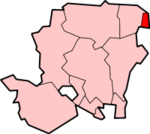
Lage in HampshireStatus Borough Region South East England Verw.grafschaft Hampshire Verwaltungssitz Farnborough Fläche 39,04 km² (321.) Einwohner 89.400 (266.) ONS-Code 24UL Website www.rushmoor.gov.uk Rushmoor ist ein Verwaltungsbezirk mit dem Status eines Borough in der Grafschaft Hampshire in England. Der Bezirk umfasst die Städte Aldershot und Farnborough. Er wurde am 1. April 1974 gebildet und entstand aus der Fusion der Urban Districts Aldershot und Farnborough.
Die Bevölkerung Rushmoors ist in den letzten zwei Jahrhunderten von 1.366 Personen im Jahr 1801 über 39.616 Personen im Jahr 1901 bis über 90.000 Personen im Jahr 2001 angestiegen. Rushmoor steht in Städtepartnerschaft mit den Städten Oberursel (Taunus) in Deutschland, Meudon in Frankreich und Sulechów in Polen.
Wahlen
Ratswahlen (elections to the council) finden in vier Jahren dreimal statt, wobei jeweils ein Drittel der Sitze im Rat gewählt wird. Seit 1973 hatten entweder die Konservativen oder keine Partei die absolute Mehrheit. Seit der Wahl im Jahr 2000 hatten die Konservativen die absolute Mehrheit. Die letzte Wahl im Jahr 2010 führte zu der folgenden Sitzverteilung: 30 Sitze für die Konservativen, 6 für die Liberaldemokraten, und 6 für die Labour Party.
Basingstoke and Deane | East Hampshire | Eastleigh | Fareham | Gosport | Hart | Havant | New Forest | Rushmoor | Test Valley | Winchester
Wikimedia Foundation.
Schlagen Sie auch in anderen Wörterbüchern nach:
Rushmoor — is a local government district and borough in Hampshire, England. It covers the towns of Aldershot and Farnborough.It was formed on 1 April 1974 by the merger of the borough of Aldershot and the Farnborough urban district. The borough took its… … Wikipedia
Rushmoor — District de Rushmoor Geographie Statut: Borough Région: Sud Est de l Angleterre Comté d administration: Hampshire … Wikipédia en Français
Rushmoor — ▪ district, England, United Kingdom borough (district), administrative and historic county of Hampshire, southern England. It occupies part of the extreme northeastern corner of the county. Rushmoor is situated at the southern edge of the… … Universalium
Rushmoor Stadium — Full name Rushmoor Stadium Location Farnborough, Hampshire Owner Farnborough F.C. Capacity 4,000+ (new stands being built) The Rushmoor Stadium is the ground of Farnborough F.C … Wikipedia
Rushmoor local elections — One third of Rushmoor Council is elected each year, followed by one year without election.Political controlNo overall control 1973 1976Conservative 1976 1980No overall control 1980 1982Conservative 1982 1995No overall control 1995… … Wikipedia
Rushmoor School — Infobox UK school name = Rushmoor School size = latitude = longitude = dms = motto = Where individuals matter motto pl = established = c.1910s approx = closed = c approx = type = Independent religion = president = head label = Head Teacher head … Wikipedia
Aldershot — infobox UK place country = England official name = Aldershot latitude = 51.2470 longitude = 0.7598 population = 58,170cite web | url=http://www.statistics.gov.uk/statbase/Expodata/Spreadsheets/D8271.csv |title=Table KS01 Usual resident population … Wikipedia
Farnborough, Hampshire — infobox UK place country = England official name= Farnborough latitude= 51.29 longitude= 0.75 scale= 50000 population = 57,147 (Census 2001) shire district= Rushmoor shire county = Hampshire region= South East England constituency westminster=… … Wikipedia
Princes Hall — Infobox Theatre name = Princes Hall caption = address = Princes Way, Aldershot city = Aldershot country = designation = latitude = longitude = owner = Rushmoor Borough Coucil capacity = 690 (seated) type = Theatre opened = 1973 yearsactive = 1973 … Wikipedia
Farnborough Airfield — Farnborough Airfield … Deutsch Wikipedia
Rushmoor

18+
© Academic, 2000-2024
- Kontaktieren Sie uns: Unterstützung, Werbung
Wörterbücher Export, schritte mit PHP, Joomla, Drupal, WordPress, MODx.