Schwarzhorn (Obersaxen GR)
- Schwarzhorn (Obersaxen GR)
-
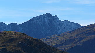
Das Schwarzhorn (rätoromanisch Piz Gren) ist der höchste Gipfel im Nordwesten der Gemeinde Obersaxen (GR) in der Schweiz (2'890 m ü. M.). Seine Westflanke fällt ab ins Val Sumvitg.
Wikimedia Foundation.
Schlagen Sie auch in anderen Wörterbüchern nach:
Schwarzhorn — ist der Name folgender Berge: Schwarzhorn (Monte Rosa Massiv) (4.322 m s.l.m.) in Italien an der Südseite der Walliser Alpen Schwarzhorn (Mattertal) (3 201 m ü. M.) in den Walliser Alpen westlich von Embd Schwarzhorn… … Deutsch Wikipedia
Schwarzhorn — may refer to:*Schwarzhorn (Monte Rosa) or Corno Nero (4322 m) in the Monte Rosa range, on southern side of the Lepontine Alps, in Italy *Schwarzhorn (Mattertal) (3201 m), west of Embd *Schwarzhorn (Binntal) (3108 m), on the border to Italy… … Wikipedia
Obersaxen — Basisdaten Staat: Schweiz Kanton … Deutsch Wikipedia
Lötschental — Vue du Lötschental Massif Alpes bernoises Pays Suisse … Wikipédia en Français
Alpes Lépontines — Carte de localisation des Alpes lépontines dans les Alpes centrales. Géographie Altitude … Wikipédia en Français
Alpes lepontines — Alpes lépontines Alpes lépontines Carte de localisation des Alpes lépontines dans les Alpes centrales. Géographie Altitude … Wikipédia en Français
Alpes lépontines — 46° 23′ 00″ N 8° 50′ 00″ E / 46.3833, 8.83333 … Wikipédia en Français