Swift Trail Junction

Swift Trail Junction
Graham County Incorporated and Unincorporated areas Swift Trail Junction highlighted.svg
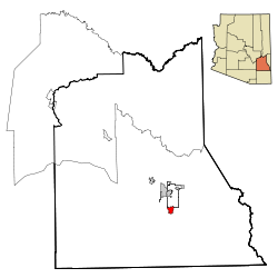
Lage im County und in Arizona
Basisdaten
Staat: Vereinigte Staaten
Bundesstaat: Arizona
County:

Graham County

Koordinaten: 32° 44′ N, 109° 43′ W32.734722222222-109.715985Koordinaten: 32° 44′ N, 109° 43′ W
Zeitzone: Mountain Standard Time (UTC−7)
Einwohner: 2195 (Stand: 2000)
Bevölkerungsdichte: 179,9 Einwohner je km²
Fläche: 12,3 km² (ca. 5 mi²)
davon 12,2 km² (ca. 5 mi²) Land
Höhe: 985 m
FIPS: 04-71650
GNIS-ID: 0024638

Swift Trail Junction ist ein Census-designated place im Graham County im US-Bundesstaat Arizona. Sie hat 2195 Einwohner auf einer Fläche von 12,3 km². Die Bevölkerungsdichte liegt bei 179,6/km². Durch Swift Trail Junction verläuft der U.S. Highway 191.


Wikimedia Foundation.

Игры ⚽ Нужна курсовая?

Schlagen Sie auch in anderen Wörterbüchern nach:

  • Swift Trail Junction — Lugar designado por el censo de los Estados Unidos …   Wikipedia Español

  • Swift Trail Junction — Swift Trail Junction, AZ U.S. Census Designated Place in Arizona Population (2000): 2195 Housing Units (2000): 561 Land area (2000): 4.718754 sq. miles (12.221516 sq. km) Water area (2000): 0.019549 sq. miles (0.050632 sq. km) Total area (2000):… …   StarDict's U.S. Gazetteer Places

  • Swift Trail Junction, AZ — U.S. Census Designated Place in Arizona Population (2000): 2195 Housing Units (2000): 561 Land area (2000): 4.718754 sq. miles (12.221516 sq. km) Water area (2000): 0.019549 sq. miles (0.050632 sq. km) Total area (2000): 4.738303 sq. miles… …   StarDict's U.S. Gazetteer Places

  • Swift Trail Junction — Original name in latin Swift Trail Junction Name in other language State code US Continent/City America/Phoenix longitude 32.72979 latitude 109.71397 altitude 982 Population 2935 Date 2011 05 14 …   Cities with a population over 1000 database

  • Swift Trail Junction, Arizona — Infobox Settlement official name = Swift Trail Junction, Arizona settlement type = CDP image caption = imagesize = image caption = imagesize = mapsize = 250px map caption = Location in Graham County and the state of Arizona mapsize1 = map… …   Wikipedia

  • Swift Communications — Inc. is an American digital marketing and newspaper publishing chain based in Carson City, Nevada. Swift s primary markets are resort town tabloid newspapers and websites. Swift Communications has been noted for being outside of the mainstream… …   Wikipedia

  • Oregon Trail — For other uses, see Oregon Trail (disambiguation). Oregon Trail The route of the Oregon Trail shown on a map of the western United States from Independence, Missouri (on the eastern end) to Oregon City, Oregon (on the western end) …   Wikipedia

  • Nashua River Rail Trail — The Nashua River Rail Trail at the Groton School Pond in Groton, MA The Nashua River Rail Trail is a 12.5 mile (20.1 km) paved mixed use rail trail in northern Massachusetts and southern New Hampshire under control of the Massachusetts… …   Wikipedia

  • Coronado Trail Scenic Byway — Karte …   Deutsch Wikipedia

  • Arizona State Route 366 — Infobox road marker state=AZ highway name= name notes= type=state route=366 alternate name= maint=ADOT length mi=28.33 length round=2 length ref=cite web |url=http://tpd.az.gov/data/reports/2006SHSLog.pdf |title=2006 ADOT Highway Log… …   Wikipedia

Share the article and excerpts

Direct link
Do a right-click on the link above
and select “Copy Link”