Tritaia

Tritaia
Gemeinde Tritea
Δήμος Τριταίας (Τριταία)
Tritea (Griechenland)
DEC
Basisdaten
Staat: Griechenland
Verwaltungsregion: Westgriechenland
Präfektur: Achaia
Geographische Koordinaten: 37° 56′ N, 21° 41′ O37.93388888888921.6763888888897Koordinaten: 37° 56′ N, 21° 41′ O
Höhe ü. d. M.: 60 m
(Durchschnitt)
Fläche: 22,3 km²
Einwohner: 5.462 (2001[1])
Bevölkerungsdichte: 244,9 Ew./km²
Gemeindesiegel:
Gemeindesiegel von Gemeinde Tritea}}}
Sitz: Stavrodromi
LAU-1-Code-Nr.: 131900
Gemeindegliederung: 14 Gemeindebezirke
Website: www.tritaia.gr
Lage in der Präfektur Achaia
Bild:Dimos tritaias.png

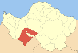
Tritea (griechisch Τριταία (f. sg.)) ist eine Gemeinde im Südwesten der Präfektur Achaia in Griechenland. Die Gemeinde hat eine Bevölkerung von 5.462 Einwohnern.

Ortsteile und Siedlungen

  • Agia Varvara
    • Agia Varvara
    • Galaros
  • Agia Marina
    • Agia Marina
    • Kato Agia Marina
  • Alepochori
  • Chiona
  • Drosia
    • Drosia
    • Kato Drosia (Agrapidies)
    • Koumberi
    • Pteri
  • Erymanthia
  • Kalfas
    • Kalfas
    • Masoureika
  • Manesi Patron
    • Golemi
    • Kato Mastrandoni
    • Manesi
    • Mastrandonis
  • Roupakia
  • Skiadas
    • Barakes
    • Karpeta
    • Pigadia
    • Skiadas
  • Skouras
    • Kardasi
    • Skouras
  • Spartia
    • Kyparissi
    • Spartia
  • Stavrodromi
    • Panouseika
    • Rachi
    • Stavrodromi
    • Xirochori
  • Velimachi

Einwohnerentwicklung

1981 hatte Tritea noch 5.051 Einwohner. Diese Zahl stieg bis 2001 um 411 auf 5.462.

Einzelnachweise

  1. Informationen des griechischen Innenministeriums

Wikimedia Foundation.

Игры ⚽ Нужно сделать НИР?

Schlagen Sie auch in anderen Wörterbüchern nach:

  • Tritaia — may also refer to an ancient city in the prefecture of Phocis, see Tritaia, Phocis Tritaia or Tritea (Greek: Τριταία) is a municipality in Achaea, Greece. Population 5,462 (2001). The seat of the municipality is in Stavrodromi. The municipality… …   Wikipedia

  • Tritaia — o Tritea (latín Tritaea) fue una ciudad de Acaya, la más al interior de las doce ciudades de los aqueos. En 280 a. C. fue una de las cuatro ciudades que encabezó la reconstrucción de la Liga Aquea. Durante la guerra social fue atacada… …   Wikipedia Español

  • Drosia, Achaea — Drosia Δροσιά Location …   Wikipedia

  • Chalandritsa — Χαλανδρίτσα Location …   Wikipedia

  • Achaea — Infobox Pref GR name = Achaea name local = Νομός Αχαΐας periph = West Greece capital = Patras population = 331,316 population as of = 2005 pop rank = 5th pop dens = 101.3 popdens rank = 9th area = 3,271.507 area rank = 14th postal code = 25x xx… …   Wikipedia

  • Farres — Φαρρές Location …   Wikipedia

  • Peiros — The first version of this article has been based in the text of of the Greek Wikipedia published under GFDL. Infobox River river name=Peiros or Piros Πείρος origin=Achaia prefecture basin country=Greece length=approximately 20 km mouth… …   Wikipedia

  • Alpochori, Achaea — Alpochori or Alpohori, also Alepochori or Alepohori (Greek: Αλποχώρι), older forms: o and on also with the e and the second i accented is a Greek village built over two mountains in the southern Achaea prefecture. Alpochori is located about 35 km …   Wikipedia

  • Kalfa — or Kalfas (Greek: Κάλφα) also with the second a accented is a Greek village built over two mountains in the southern Achaea prefecture. Drosia is located south of Patras, west of Kalavryta, northwest of Tripoli, north of Lampeia and northeast of… …   Wikipedia

  • Achäischer Bund — Karte der antiken Landschaft Achaia aus dem historischen Atlas von William Shepard von 1926 (Südteil) Der Achaiische Bund war ein Bündnis des nordpeloponnesischen Stammes der Achaier im antiken Griechenland, zu dem später 12 Poleis gehörten. Der… …   Deutsch Wikipedia

Share the article and excerpts

Direct link
Do a right-click on the link above
and select “Copy Link”