- Tungawan
-
Municipality of Tungawan Lage von Tungawan in der Provinz Zamboanga Sibugay 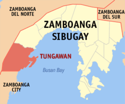
Basisdaten Bezirk: Zamboanga Peninsula Provinz: Zamboanga Sibugay Barangays: 25 Distrikt: 3. Distrikt von Zamboanga Sibugay PSGC: 098316000 Einkommensklasse: 3. Einkommensklasse Haushalte: 6453 Zensus 1. Mai 2000Einwohnerzahl: 37.588 Zensus 1. August 2007Koordinaten: 7° 30′ N, 122° 22′ O7.5122.36666666667Koordinaten: 7° 30′ N, 122° 22′ O Bürgermeister: Randy Adlwaon Climaco Offizielle Webpräsenz: www.tungawansibugay.gov.ph Geographische Lage auf den Philippinen 

Tungawan Tungawan ist eine philippinische Stadtgemeinde in der Provinz Zamboanga Sibugay. Nach dem Zensus vom 1. Mai 2000 hat sie 33.194 Einwohner in 6453 Haushalten.
Baranggays
Tungawan ist politisch in 25 Baranggays unterteilt.
- Baluran
- Batungan
- Cayamcam
- Datu Tumanggong
- Gaycon
- Langon
- Libertad (Pob.)
- Linguisan
- Little Margos
- Loboc
- Looc-labuan
- Lower Tungawan
- Malungon
- Masao
- San Isidro
- San Pedro
- San Vicente
- Santo Niño
- Sisay
- Taglibas
- Tigbanuang
- Tigbucay
- Tigpalay
- Timbabauan
- Upper Tungawan
Schlagen Sie auch in anderen Wörterbüchern nach:
Tungawan — Original name in latin Tungawan Name in other language Lower Tungawan, Tungauan, Tungawan State code PH Continent/City Asia/Manila longitude 7.50806 latitude 122.37111 altitude 14 Population 3603 Date 2011 07 31 … Cities with a population over 1000 database
Tungawan, Zamboanga Sibugay — Infobox Philippine municipality infoboxtitle = Municipality of Tungawan sealfile = locatormapfile = Ph locator zamboanga sibugay tungawan.png caption = Map of Zamboanga Sibugay showing the location of Tungawan. region = Zamboanga Peninsula… … Wikipedia
Western Mindanao State University — Infobox University name = Western Mindanao State University established = 1904 type = Public, State University president = Dr. Grace J. Rebollos city = Zamboanga City state = Zamboanga del Sur country = Philippines undergrad = 17,000 postgrad = 2 … Wikipedia
PH-ZSI — Lage von Zamboanga Sibugay Zamboanga Sibugay nimmt den südöstlichen Bereich der Halbinsel Zamboanga auf der Insel Mindanao ein und ist eine Provinz der Philippinen. Die Hauptstadt der Provinz ist die Gemeinde Ipil. Zamboanga Sibugay gehört zum… … Deutsch Wikipedia
Diplahan, Zamboanga Sibugay — Diplahan Municipality Map of Zamboanga Sibugay showing the location of Diplahan … Wikipedia
Malangas, Zamboanga Sibugay — Municipality of Malangas … Wikipedia
Naga, Zamboanga Sibugay — Naga Municipality Map of Zamboanga Sibugay showing the location of Naga … Wikipedia
Olutanga, Zamboanga Sibugay — Olutanga Municipality Map of Zamboanga Sibugay showing the location of Olutanga … Wikipedia
Sominot, Zamboanga del Sur — Sominot is a 5th class municipality in the province of Zamboanga del Sur, Philippines. According to the 2000 census, it has a population of 14,815 people in 2,913 households.BarangaysSominot is politically subdivided into 18 barangays. * Bag ong… … Wikipedia
List of cities and municipalities in the Philippines — This is a list of cities and municipalities in the Philippines arranged by province and in alphabetical order. As of 2006, there are 118 cities and 1509 municipalities.As of September 4, 2007, there are 136 cities, 1,495 municipalities, 81… … Wikipedia
Tungawan


18+
© Academic, 2000-2024
- Kontaktieren Sie uns: Unterstützung, Werbung
Wörterbücher Export, schritte mit PHP, Joomla, Drupal, WordPress, MODx.