Yiali

Yiali
Gyali
Abbau von Bimsstein auf Gyali
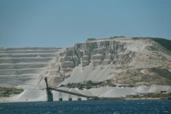
Gewässer Mittelmeer
Inselgruppe Dodekanes
Geographische Lage 36° 40′ 0″ N, 27° 7′ 0″ O36.66666666666727.116666666667180Koordinaten: 36° 40′ 0″ N, 27° 7′ 0″ O
Gyali (Griechenland)
DEC
Gyali
Länge 6 km
Breite 4 km
Fläche 5 km²dep1
Höchste Erhebung 180 m
Einwohner (unbewohnt)

Gyali (griechisch Γυαλί [ʝaˈli] (n. sg.), im Altertum Istros genannt) ist eine kleine, unbewohnte (1991 hatte sie noch 16 Einwohner) griechische Insel in der Ägäis etwa acht Kilometer südlich von Kos und 3,5 Kilometer nördlich von Nisyros.

Die Insel ist sechs Kilometer lang und zwischen vier Kilometern und 500 Metern breit. Sie erreicht eine Höhe von 180 Meter und ist vegetationsarm. Die Insel besteht aus zwei fast gleich großen Teilen, die durch einen schmalen Strand verbunden sind. Der nordöstliche Teil besteht größtenteils aus Obsidian, der südwestliche aus Bimsstein.

Gyali ist vulkanischen Ursprungs. Schon in vorgeschichtlicher Zeit wurde auf der Insel Obsidian für Werkzeuge gewonnen. Nachgewiesen sind Funde aus der Jungsteinzeit auf dem 200 Kilometer entfernten Saliagos. Heute wird auf der Insel in großem Stil Bimsstein abgebaut, was das Aussehen der zu Nisyros gehörenden Insel stark verändert hat.

Der Vulkan der Insel Gyali brach laut Thermolumineszenzdatierung etwa 1460 v. Chr. aus[1] und damit relativ zeitnah zur Minoischen Eruption der Vulkaninsel Santorin.

Einzelnachweise

  1. I. Liritzis et al.: A significant aegean volcanic eruption during the second millennium B.C. revealed by thermoluminescence dating. In: Geoarchaeology. Band 11, S. 361–371. 

Weblinks

Gyali im Global Volcanism Program der Smithsonian Institution (englisch)


Wikimedia Foundation.

Игры ⚽ Поможем написать реферат

Schlagen Sie auch in anderen Wörterbüchern nach:

  • Gyali — Infobox Greek Isles name = Gyali native name = Γυαλί skyline = Yiali.jpg sky caption = Pumice mining on Gyali coordinates = coord|36|40|N|27|07|E chain = Dodecanese isles = area = highest mount = Volcano elevation = 180 periph = South Aegean… …   Wikipedia

  • Gyali — Γυαλί canteras de piedra pómez en Gyali Localización País …   Wikipedia Español

  • Obsidian — For other uses, see Obsidian (disambiguation). Obsidian Obsidian from Lake Cou …   Wikipedia

  • Yalova — is a city located in northwestern Turkey, on the eastern coast of the Sea of Marmara, and is the capital of the Yalova Province. Yalova has a city population of 70,858, while the population of the Yalova Province is 188,440. Etymology In general …   Wikipedia

  • Yalı (residence) — A yalı (Turkish: yalı , from Greek yiáli γιαλή (mod. γιαλός ), literally seashore, beach [ [http://www.tdk.gov.tr/TR/SozBul.aspx?F6E10F8892433CFFAAF6AA849816B2EF4376734BED947CDE Kelime=yal%c4%b1 TDK Online Yalı entry] ] [… …   Wikipedia

  • Yalova — Administration Pays …   Wikipédia en Français

  • Yalova — Para otros usos de este término, véase Provincia de Yalova. Yalova Bandera …   Wikipedia Español

  • Aegean civilizations — The Bronze Age civilizations that arose and flourished с 3000–1000 BC in the region bordering the Aegean Sea. They included Crete, the Cyclades, the Greek mainland south from Thessaly, including the Peloponnese, and Macedonia, Thrace, and western …   Universalium

  • Yalı — de Kıbrıslı Mehmed Emin Pasha à Kandilli, le long du rivage asiatique d Istanbul sur le Bosphore Un yalı (turc : yalı, du grec yiáli γιαλή (mod. γιαλός), littéralement « rivage, plage » est une demeure …   Wikipédia en Français

Share the article and excerpts

Direct link
Do a right-click on the link above
and select “Copy Link”