- Bitihorn
-
Bitihorn 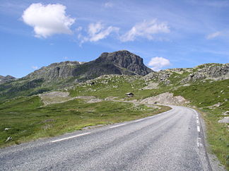
Bitihorn von Süden (Riksvei 51)
Höhe 1.608 m Lage Norwegen, Oppland Gebirge Jotunheimen Geographische Lage 61° 17′ 43″ N, 8° 47′ 55″ O61.2952777777788.79861111111111608Koordinaten: 61° 17′ 43″ N, 8° 47′ 55″ O 

Erstbesteigung 1811 durch Christen Smith Das Bitihorn ist eine Bergspitze im südöstlichen Jotunheimen in Norwegen.
Es liegt auf dem Gebiet der Kommunen Vang und Øystre Slidre; der Gipfel markiert die Kommunengrenze. Der Riksvei 51 führt östlich am Bitihorn vorbei.
Auf dem westlich vom Berg gelegenen See Bygdin verkehrt seit 1912 ein Schiff, das den Namen Bitihorn trägt.[1]
Einzelnachweise
- ↑ ADAC Reiseführer Norwegen: Jotunheimen. Abgerufen am 9. Juli 2008.
Kategorien:- Eintausender
- Skandinavisches Gebirge
- Berg in Europa
- Berg in Norwegen
- Geographie (Oppland)
- Vang
- Øystre Slidre


Wikimedia Foundation.