- Ash Creek (Utah)
-
Ash Creek (Utah) 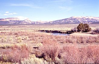
Der Ash Creek bei Pintura, mit Blick auf die Hurricane Cliffs
Daten Gewässerkennzahl US: 1438278 Lage Washington County, Utah, USA Flusssystem Colorado River Abfluss über Virgin → Colorado → Golf von Kalifornien Ursprung Zusammenfluss von North Ash Creek und dem Fluss im Sawyer Canyon
37° 26′ 26″ N, 113° 16′ 10″ W37.4405362-113.2693947Mündung zusammen mit dem La Verkin Creek bei La Verkin in den Virgin River 37.203316-113.2882817Koordinaten: 37° 12′ 12″ N, 113° 17′ 18″ W
37° 12′ 12″ N, 113° 17′ 18″ W37.203316-113.2882817Länge 55 km Der Ash Creek ist ein etwa 55 km langer, linksseitiger Nebenfluss des La Verkin Creeks im Südwesten des US-Bundesstaates Utah. Er gehört dem Flusssystem des Colorado Rivers an, entspringt etwa 10 km westlich von Kanaraville an den Hurricane Cliffs und fließt zunächst nach Westen. Bei Kanaraville macht er einen Knick nach Südwesten und fließt in einem weiten Tal bis hinter Pintura, wo er erneut abknickt und zwar nach Süden. Diese Fließrichtung behält er bis zu seiner Einmündung in den La Verkin Creek bei La Verkin bei. Unweit südlich fließen beide zusammen in den Virgin River, einen rechtsseitigen Nebenfluss des Colorado Rivers. Erosionsbasis für den Ash Creek ist also der Golf von Kalifornien, ein Nebenmeer des Pazifischen Ozeans.
Im flachen Muldental des Ash Creeks verläuft mit dem Interstate Highway 15 zwischen Las Vegas und Salt Lake City eine Hauptverkehrsachse des Staates Utah. Ein weiterer Ort am Ash Creek ist Toquerville.
Kategorien:- Flusssystem Colorado River
- Fluss in Utah
- Fluss in Nordamerika

Wikimedia Foundation.