- Brunet Island State Park
-
Brunet Island State Park IUCN-Kategorie V 

Lage: Cornell, Wisconsin, USA Geographische Lage: 45° 11′ N, 91° 10′ W45.179166666667-91.166388888889Koordinaten: 45° 10′ 45″ N, 91° 9′ 59″ W Fläche: 496 ha Einrichtungsdatum: 1936 Verwaltungsbehörde: Wisconsin Department of Natural Resources Der Brunet Island State Park [ˈbruːneɪ] ist ein State Park auf einer Insel im Chippewa River in Wisconsin.
Inhaltsverzeichnis
Geschichte
1936 spendete die Northern States Power Company Brunet Island an den Staat Wisconsin. Der State Park wurde 1940 zu Ehren von Jean Brunet gegründet. 1938 wurde eine Schutzhütte von den Civilian Conservation Corps errichtet, die 2003 renoviert wurde. 1970 und 1977 wurde der State Parks von zwei Tornados heimgesucht.
Geographie
Der State Park liegt auf einer gleichnamigen Insel am Zusammenschluss von Chippewa und Fisher River.
Fauna
Im State Park gibt es eine Überpopulation von Weißwedelhirschen sowie Rauhfußhühner. Weiterhin gibt es Eichhörnchen, Füchse, Stachelschweine, Skunks, Streifenhörnchen, Waldmurmeltiere und Waschbären. Im Wasser leben Biber, Bisamratten, Nerze und Otter. Als Vogelarten kommen Fisch- und Weißkopfseeadler sowie Eulen und Kanadareiher vor.
Flora
Im State Park kommen Kanadische Hemlocktannen vor. Das Gebiet, das 1977 von einem Tornado zerstört wurde ist heutzutage mit Birken, Eichen und Espen bepflanzt. Daneben kommen verschiedene Wildblumen, Farne, Moose, und Flechten sowie Bärlapppflanzen und Beeren vor.
Wanderwege
 Jean Brunet Nature Trail
Im Brunet Island State Park beginnt der Old Abe State Trail. Außerdem gibt es die folgenden 12,8 km Wanderwege:
- Jean Brunet Nature Trail (1,3 km)
- Nordic Trail
- Pine Trail
- Spruce Trail
- Timber Trail
Weblinks
- Offizielle Webseite des State Parks
- Karte des State Parks (PDF-Dokument, 52 KB)
- Brunet Island State Park im Geographic Names Information System des United States Geological Survey
Amnicon Falls | Aztalan | Belmont Mound | Big Bay | Big Foot Beach | Blue Mound | Brunet Island | Buckhorn | Capital Springs | Copper Culture | Copper Falls | Council Grounds | Devil’s Lake | Governor Dodge | Governor Nelson | Governor Thompson | Harrington Beach | Hartman Creek | Heritage Hill | High Cliff | Interstate | Kinnickinnic | Kohler-Andrae | Lake Kegonsa | Lake Wissota | Lakeshore | Merrick | Mill Bluff | Mirror Lake | Natural Bridge | Nelson Dewey | New Glarus Woods | Newport | Pattison | Peninsula | Perrot | Potawatomi | Rib Mountain | Roche-a-Cri | Rock Island | Rocky Arbor | Straight Lake | Tower Hill | Whitefish Dunes | Wildcat Mountain | Willow River | Wyalusing | Yellowstone Lake
Wikimedia Foundation.
Schlagen Sie auch in anderen Wörterbüchern nach:
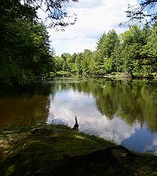
Brunet Island State Park — Geobox|Protected area name = Brunet Island State Park category = Wisconsin State Park category iucn = V image caption = Backwater channels at the north end of Brunet Island attract canoeists and wildlife watchers. country = United States country… … Wikipedia
Lake Wissota State Park — Geobox|Protected area name = Lake Wissota State Park category = Wisconsin State Park category iucn = V image caption = Lake Wissota State Park s mix of prairie and forest is situated on the northeast shore of Lake Wissota. country = United States … Wikipedia
Mill Bluff State Park — Coordinates: 43°56′47″N 90°18′55″W / 43.94639°N 90.31528°W / 43.94639; 90.31528 … Wikipedia
Copper Culture State Park — Oconto Site U.S. National Register of Historic Places U.S. National Historic Landmark … Wikipedia
Mirror Lake State Park — For the lake in Waupaca, Wisconsin, see Mirror Lake (Waupaca). Coordinates: 43°33′54″N 89°49′12″W / 43.565°N 89.82°W / … Wikipedia
Copper Falls State Park — Coordinates: 46°22′35″N 90°38′36″W / 46.37639°N 90.64333°W / 46.37639; 90.64333 … Wikipedia
Council Grounds State Park — Coordinates: 45°11′7″N 89°44′35″W / 45.18528°N 89.74306°W / 45.18528; 89.74306 … Wikipedia
Nelson Dewey State Park — Coordinates: 42°43′51″N 91°1′10″W / 42.73083°N 91.01944°W / 42.73083; 91.01944 … Wikipedia
Blue Mound State Park — IUCN Kategorie V Lage … Deutsch Wikipedia
Big Bay State Park — IUCN Kategorie V … Deutsch Wikipedia
Brunet Island State Park

18+
© Academic, 2000-2024
- Kontaktieren Sie uns: Unterstützung, Werbung
Wörterbücher Export, schritte mit PHP, Joomla, Drupal, WordPress, MODx.