Claysville S Bridge

Claysville S Bridge
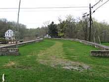
Die „S Bridge“ von der Ostseite

Die S Bridge ist eine historische Steinbrücke (Bogenbrücke), und liegt etwa 10 Kilometer westlich von Washington, im Washington County, im US-Bundesstaat Pennsylvania, in den Vereinigten Staaten. Die um 1815 errichtete Fußgängerbrücke liegt abseits des U.S. Highway 40, und überspannt den Buffalo Creek.

Laut National Register of Historic Places war die Brücke im Jahr 1818 von besonderer Signifikanz.

Die S-Bridge wurde am 4. April 1975 vom National Register of Historic Places mit der Nummer 75001676 aufgenommen.[1]

Einzelnachweise

  1. NRIS
40.139444444444-80.349722222222

Wikimedia Foundation.

Игры ⚽ Поможем решить контрольную работу

Schlagen Sie auch in anderen Wörterbüchern nach:

  • Claysville S Bridge — S Bridge U.S. National Register of Historic Places Washington County History Landmarks Foundation Landmark …   Wikipedia

  • Claysville Church — Located at the intersection of the Northwestern Turnpike(Now US 50) and WV Rt. 93 in Claysville, Mineral County, West Virginia Claysville Church was built in 1850 under the direction of Daniel Hendrickson and John Fout, local contractor and fund… …   Wikipedia

  • S Bridge — in Guernsey County S Bridge ist die englischsprachige Bezeichnung für eine Brücke über ein Gewässer, deren Grundriss S förmig gebogen ist. Die S förmige Bauweise ist unter anderem aus Ohio im beginnenden 19. Jahrhundert bekannt. Diese Art der… …   Deutsch Wikipedia

  • National Register of Historic Places listings in Washington County, Pennsylvania — Location of Washington County in Pennsylvania This is a list of the National Register of Historic Places listings in Washington County, Pennsylvania. This is intended to be a complete list of the properties and districts on the National Register… …   Wikipedia

  • National Register of Historic Places listings in Guernsey County, Ohio — Location of Guernsey County in Ohio This is a list of the National Register of Historic Places listings in Guernsey County, Ohio. This is intended to be a complete list of the properties and districts on the National Register of Historic Places… …   Wikipedia

  • Northwestern Turnpike — The Northwestern Turnpike is a historic road in West Virginia (Virginia at the time the road was created), important for being historically one of the major roads crossing the Appalachians, financed by the Virginia Board of Public Works in the… …   Wikipedia

  • Mineral County, West Virginia — Location in the state of West Virginia …   Wikipedia

  • U.S. Route 40 in Pennsylvania — This article is about the section of U.S. Route 40 in Pennsylvania. For the entire length of the highway, see U.S. Route 40. U.S. Route 40 National Road Route information …   Wikipedia

  • Interstate 70 in Pennsylvania — This article is about the section of Interstate 70 in Pennsylvania. For the entire length of the highway, see Interstate 70. Interstate 70 …   Wikipedia

  • New Creek — at Keyser, West Virginia in 1996 New Creek is an 18.4 mile long (29.6 km)[1] stream in eastern West Virginia in the United States. It is the third major West Virginia tributary to the North Branch Potomac River …   Wikipedia

Share the article and excerpts

Direct link
Do a right-click on the link above
and select “Copy Link”