Lake Burbury

Lake Burbury
Lake Burbury
Lake Burbury.jpg
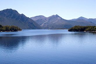
Geographische Lage West Coast Range, Tasmanien
Zuflüsse King River, Nelson River, Princess River, Eldon River
Größere Städte in der Nähe Queenstown
Daten
Koordinaten 42° 7′ 0″ S, 145° 40′ 0″ O-42.116666666667145.66666666667Koordinaten: 42° 7′ 0″ S, 145° 40′ 0″ O
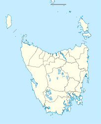
Lake Burbury (Tasmanien)
Lake Burbury
Fläche 54 km²f5

Lake Burbury ist ein Stausee im Westen des australischen Bundesstaats Tasmanien. Er bildete sich durch die Aufstauung mehrerer Flüsse Anfang der 1990er Jahre, darunter hauptsächlich des King River und des Eldon River. Der See wurde nach einem früheren Gouverneur von Tasmanien, Stanley Burbury, benannt.

Der See ist trotz des häufig wechselhaften Wetters ein beliebtes Fischgebiet, vorrangig für Regenbogen- und Bachforellen. Er befindet sich heute auf dem Gebiet des Franklin-Gordon-Wild-Rivers-Nationalparks.

Weblinks


Wikimedia Foundation.

Игры ⚽ Нужна курсовая?

Schlagen Sie auch in anderen Wörterbüchern nach:

  • Lake Burbury — Infobox lake lake name = Lake Burbury image lake = Lake Burbury.jpg caption lake = image bathymetry = caption bathymetry = location = West Coast Range, Tasmania coords = coord|42|07|S|145|40|E|region:AU TAS type:waterbody|display=inline,title… …   Wikipedia

  • Lake Beatrice — Infobox lake lake name = Lake Beatrice image lake = caption lake = image bathymetry = caption bathymetry = location = West Coast, Tasmania coords = coord|42|00|S|145|32|E|type:waterbody region:AU TAS|display=inline,title type = Natural Lake… …   Wikipedia

  • Stanley Burbury — Infobox Prime Minister name =Stanley Charles Burbury birth date =birth date|1909|12|3|df=y birth place =Western Australia, Australia death date =death date and age|1995|4|24|1909|12|3|df=y death place =Hobart, Tasmania, Australia spouse = order… …   Wikipedia

  • West Coast Range — The West Coast Range (coord|42|05|S|145|36|E|region:AU TAS type:mountain) of Tasmania is a group of mountains in the West Coast area of Tasmania in Australia that lies to the west of the Franklin Gordon Wild Rivers National ParkThe range has had… …   Wikipedia

  • Бербери (озеро) — Бербери Lake Burbury Координаты: Координаты …   Википедия

  • Crotty Dam — Location West Coast Tasmania Coordinates 42°09′35″S 145°37′00″E …   Wikipedia

  • Crotty Dam, Tasmania — Crotty Dam also known earlier as the King River Dam is an 80metre high concrete faced rock and gravel fill dam in Tasmania.It is one of two dams that contain Lake Burbury, on the West Coast.It captures the high rainfall in the catchment of the… …   Wikipedia

  • Mount Jukes (Tasmania) — Mount Jukes Elevation 1,104 m (3,622 ft) Location Location …   Wikipedia

  • Mount Owen (Tasmania) — Mount Owen Elevation 1,146 m (3,760 ft) Location Location …   Wikipedia

  • Кинг (река, Тасмания) — У этого термина существуют и другие значения, см. Кинг. Кинг King River Река Кинг в районе впадения в неё рек …   Википедия

Share the article and excerpts

Direct link
Do a right-click on the link above
and select “Copy Link”