Loch Insh

Loch Insh
Loch Insh
Loch Insh mit der Insel Tom Dubh
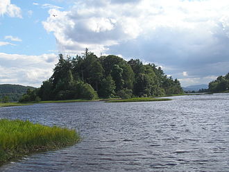
Geographische Lage Highland, Schottland
Zuflüsse Spey
Abfluss Spey → Moray FirthNordsee
Inseln Tom Dumbh
Orte am Ufer Kincraig
Größere Städte in der Nähe Aviemore
Daten
Koordinaten 57° 7′ 0″ N, 3° 56′ 0″ W57.116666666667-3.9333333333333216Koordinaten: 57° 7′ 0″ N, 3° 56′ 0″ W
Loch Insh (Schottland)
Loch Insh
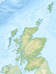
Höhe über Meeresspiegel 216 m ASL
Länge 1,8 kmf6
Breite 1 kmf7

Loch Insh ist ein Süßwassersee im schottischen Hochland. Er liegt im Tal des Flusses Spey in der Unitary Authority Highland. Der See ist circa 1,8 km lang und etwa 1 km breit.

Loch Insh wird vom River Spey durchflossen. Der Spey mündet in Loch Insh an dessen westlichem Ende und verlässt den See wieder an dessen Ostufer. Außerdem mündet der Dunachton Burn im Norden in Loch Insh. Unmittelbar vor dem Ausfluss des Spey befindet sich im See eine Insel - Tom Dumbh genannt.

Am Nordufer des Loch Insh liegt das Dorf Kincraig. Das Ostufer beherbergt seit 1969 ein Wassersportzentrum, von dem aus Segel- und Kajakausflüge auf dem See unternommen werden können. Loch Insh wird im Nordwesten sowohl von der A9 als auch von der B9152 erschlossen. Am südöstlichen Ufer verläuft die B970. Der See ist mit dem Auto daher sehr einfach zu erreichen. Entlang dem nordwestlichen Ufer verläuft außerdem eine Bahnstrecke, die aber über keinen in Seenähe gelegenen Bahnhof verfügt.

Loch Insh ist außerdem ein Angelgebiet, in dem sowohl von Booten als auch vom Ufer aus gefischt werden kann. Gefangen werden vor allem Lachse und Forellen.

Weblinks

Loch Insh von einer Anhöhe im Norden des Sees fotografiert

Wikimedia Foundation.

Игры ⚽ Нужен реферат?

Schlagen Sie auch in anderen Wörterbüchern nach:

  • Loch Insh — Le loch Insh Administration Pays …   Wikipédia en Français

  • Loch Insh — Infobox lake lake name = Loch Insh image lake = caption lake = image bathymetry = caption bathymetry = location = Highlands, Scotland coords = coord|57|07|N|3|55|W|region:GB type:waterbody source:GNS enwiki|display=inline,title type = freshwater… …   Wikipedia

  • HMS Loch Insh (K433) — was a Loch class frigate of the Royal Navy. She was built by Henry Robb of Leith and launched on 10 May 1943. She was named after Loch Insh in Scotland.She served in World War II. On 29 April 1945, in the Barents Sea she assisted Anguilla and… …   Wikipedia

  • Insh —    INSH, lately a quoad sacra parish, formed of part of the parish of Kingussie, and a small part of that of Alvie, in the county of Inverness; containing 613 inhabitants, of whom 88 are in the village of Insh, 7 miles (N. E.) from Pitmain. This… …   A Topographical dictionary of Scotland

  • Loch class frigate — The Loch class was a class of anti submarine (A/S) frigate built for the Royal Navy and her allies during World War II. They were an innovative design based on the experience of 3 years of fighting in the Battle of the Atlantic and attendant… …   Wikipedia

  • Pantanos de Insh — Saltar a navegación, búsqueda Los Pantanos de Insh (en inglés, Insh Marshes) son 10 kilómtros cuadrados de planicie aluvial del río Spey entre Kingussie y Kincraig en Badenoch and Strathspey, Highland, Escocia (Reino Unido). Quedan a ambos lados… …   Wikipedia Español

  • Highland Railway Loch Class — Infobox Locomotive name = Highland Railway Loch class powertype = Steam caption = designer = David Jones builder = flagicon|Scotland Dübs Co. (15)flagicon|Scotland North British Loco (3) whytetype = 4 4 0 gauge = RailGauge|ussg builddate = 1896… …   Wikipedia

  • Liste schottischer Lochs — Loch ist das schottisch gälische Wort für einen See oder eine Meeresbucht, einen Fjord (englisch Firth). Das Wort, lɔx, «loch» mit kehligem «ch» ausgesprochen, ist verwandt mit dem altirischen Lough, rekonstruierte indogermanische Wurzel… …   Deutsch Wikipedia

  • Battle of Dun Nechtain — Part of the Pictish Northumbrian conflicts …   Wikipedia

  • Kingussie —    KINGUSSIE, a parish, in the Mainland district of the county of Inverness, ½ a mile (E. by N.) from Pitmain; containing, with part of the late quoad sacra parish of Insh, the villages of Kingussie and Newtonmore, and the hamlet of Ralia, 2047… …   A Topographical dictionary of Scotland

Share the article and excerpts

Direct link
Do a right-click on the link above
and select “Copy Link”