- Chautauqua County (New York)
-
Verwaltung US-Bundesstaat: New York Verwaltungssitz: Mayville Adresse des
Verwaltungssitzes:Chautauqua County Gov. Offices
3 North St.
Mayville, NY 14757Gründung: 11. März 1808 Gebildet aus: Genesee County Vorwahl: 001 716 Demographie Einwohner: 139.750 (2000) Bevölkerungsdichte: 50,8 Einwohner/km² Geographie Fläche gesamt: 3.885 km² Wasserfläche: 1.134 km² Karte 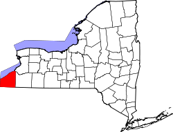
Website: www.co.chautauqua.ny.us Chautauqua County[1] ist ein County im Bundesstaat New York der Vereinigten Staaten von Amerika. Bei der Volkszählung im Jahr 2000 hatte das County 139.750 Einwohner und eine Bevölkerungsdichte von 51 Einwohnern pro Quadratkilometer. Der Verwaltungssitz (County Seat) ist Mayville.
Geografie
Das County hat eine Fläche von 3885 Quadratkilometern, wovon 1134 Quadratkilometer Wasserfläche sind. Chautauqua County grenzt im Norden an den Eriesee, im Nordosten an Erie County (New York), im Osten an Cattaraugus County, im Süden an Warren County (Pennsylvania) und im Südwesten an Erie County (Pennsylvania).
Städte und Ortschaften
Städte Gemeinden Dörfer - Dunkirk
- Jamestown
- Arkwright
- Busti
- Carroll
- Charlotte
- Chautauqua
- Cherry Creek
- Clymer
- Ellery
- Ellicott
- Ellington
- French Creek
- Gerry
- Hanover
- Harmony
- Kiantone
- Mina
- North Harmony
- Poland
- Pomfret
- Portland
- Ripley
- Sheridan
- Sherman
- Stockton
- Villenova
- Westfield
- Bemus Point
- Brocton
- Cassadaga
- Celoron
- Cherry Creek
- Falconer
- Forestville
- Fredonia
- Lakewood
- Mayville
- Panama
- Sherman
- Silver Creek
- Sinclairville
- Westfield
Einzelnachweise
- ↑ GNIS-ID: 974105. Abgerufen am 22. Februar 2011 (englisch).

Liste der Countys in New York
Albany | Allegany | Bronx | Broome | Cattaraugus | Cayuga | Chautauqua | Chemung | Chenango | Clinton | Columbia | Cortland | Delaware | Dutchess | Erie | Essex | Franklin | Fulton | Genesee | Greene | Hamilton | Herkimer | Jefferson | Kings (Brooklyn) | Lewis | Livingston | Madison | Monroe | Montgomery | Nassau | New York (Manhattan) | Niagara | Oneida | Onondaga | Ontario | Orange | Orleans | Oswego | Otsego | Putnam | Queens | Rensselaer | Richmond (Staten Island) | Rockland | Saratoga | Schenectady | Schoharie | Schuyler | Seneca | St. Lawrence | Steuben | Suffolk | Sullivan | Tioga | Tompkins | Ulster | Warren | Washington | Wayne | Westchester | Wyoming | Yates
Wikimedia Foundation.
Schlagen Sie auch in anderen Wörterbüchern nach:
Chautauqua County, New York — This article is about the county in New York. For other uses of Chautauqua, see Chautauqua (disambiguation). Chautauqua County, New York … Wikipedia
State highways in Chautauqua County, New York — Map locating where Chautauqua County is in New York Chautauqua County, New York has eighteen currently state maintained highways[1] which comprise a combined 386.7 miles (622.3 km) of the touring route total mileage … Wikipedia
National Register of Historic Places listings in Chautauqua County, New York — Location of Chautauqua County in New York List of the National Register of Historic Places listings in Chautauqua County, New York … Wikipedia
List of county routes in Chautauqua County, New York — The following is a list of county routes in Chautauqua County, New York. All county routes in Chautauqua County are signed with the standard blue pentagonal shield. Even numbered routes are west–east roads, while odd numbered routes are… … Wikipedia
Poland, Chautauqua County, New York — There is a Village with this name in Herkimer County, New York. Poland is a town in Chautauqua County, New York, U.S. The population was 2,467 at the 2000 census.The Town of Poland is on the county s eastern border.HistoryThe town was first… … Wikipedia
Cattaraugus Reservation, Chautauqua County, New York — Cattaraugus Reservation is an Indian reservation of the Seneca tribe, located partly in Chautauqua County, New York, United States. The population was 23 at the 2000 census. Most of the inhabitants are of the Seneca tribe. This part of the… … Wikipedia
Elmhurst, Chautauqua County, New York — Elmhurst, a neighborhood located in Fluvanna, is a place in Chautauqua County in the State of New York in the United States of America. It is located at latitude 42°7 5 North, longitude 79°17 38 West.Elmhurst is also the name of a neighborhood in … Wikipedia
Cattaraugus County, New York — Coordinates: 42°14′N 78°41′W / 42.24°N 78.68°W / 42.24; 78.68 … Wikipedia
Richmond County (New York) — Verwaltung US Bundesstaat: New York Verwaltungssitz: Adresse des Verwaltungssitzes: Gründung: 1683 … Deutsch Wikipedia
Erie County, New York — Infobox U.S. County county = Erie County state = New York map size = 250 founded = 1821 seat = Buffalo | area total sq mi =1227 area land sq mi =1044 area water sq mi =183 area percentage = 14.89% census yr = 2000 pop = 950265 density km2 =351… … Wikipedia
Chautauqua County (New York)

18+
© Academic, 2000-2024
- Kontaktieren Sie uns: Unterstützung, Werbung
Wörterbücher Export, schritte mit PHP, Joomla, Drupal, WordPress, MODx.