- Mont Oave
-
Mont Oave 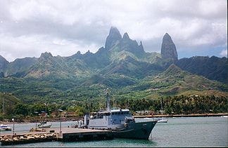
Mont Oave von Hakahau aus gesehen
Höhe 1.232 m Lage Ua Pou, Marquesas, Französisch-Polynesien Geographische Lage 9° 23′ 30″ S, 140° 4′ 42″ W-9.3916666666667-140.078333333331232Koordinaten: 9° 23′ 30″ S, 140° 4′ 42″ W 

Gestein Basalt Alter des Gesteins 2,54 – 4,68 Mio. Jahre[1] Besonderheiten Höchster Berg der Marquesas-Inseln Der Mont Oave ist zugleich der höchste Berg der Insel Ua Pou als auch die höchste Erhebung der Marquesas-Inseln in Französisch-Polynesien. Die für viele Marquesas charakteristische, nadelförmige Erhebung aus Basalt liegt im Zentrum der Insel und erreicht eine Höhe von 1232 m über dem Meer. Der Berg ist vulkanischen Ursprungs und gehört zur „Marquesas linear volcanic chain“, die sich aus einem Hotspot der Pazifischen Platte gebildet hat und sich mit einer Geschwindigkeit von 103 - 118 mm pro Jahr in Richtung Westnordwest bewegt.[2]
Weblinks
- Mont Oave bei Peakbagger.com (englisch)
Einzelnachweise
Kategorien:- Eintausender
- Berg in Französisch-Polynesien
- Berg in Australien und Ozeanien
- Marquesas-Inseln


Wikimedia Foundation.