Pilot Island (Wisconsin)

Pilot Island (Wisconsin)

Vorlage:Infobox Insel/Wartung/Höhe fehlt

Pilot Island
Leuchtturm auf Pilot Island
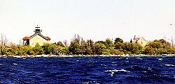
Gewässer Michigansee
Geographische Lage 45° 17′ 6″ N, 86° 55′ 11″ W45.285-86.919722222222Koordinaten: 45° 17′ 6″ N, 86° 55′ 11″ W
Pilot Island (Wisconsin)
Pilot Island
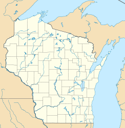
Fläche 1,5 ha

Pilot Island (wörtlich „Lotseninsel“) ist eine 1,5 ha große Insel im Michigansee. Sie gehört zum Door County im Nordosten des US-Bundesstaats Wisconsin und wurde ursprünglich als Standort für einen Leuchtturm erschlossen.[1] Der 1858 erbaute Leuchtturm ist heute noch in Betrieb.[2]

Pilot Island ist Teil des Green Bay National Wildlife Refuge und dient dem Schutz des Lebensraums einheimischer Vögel und bedrohter Arten. So gibt es auf der Insel Brutkolonien von Ohrenscharben und Amerikanischen Silbermöwen. Auch einige Kanadareiher und Nachtreiher brüten auf Pilot Island. Wegen des Vorkommens bodenbrütender Zugvögel und da die Insel nur eingeschränkt und schwer zugänglich ist, ist die allgemeine, öffentliche Nutzung untersagt.[1]

Einzelnachweise

  1. a b U.S. Fish & Wildlife Service: Green Bay National Wildlife Refuge. Abgerufen am 13. Juli 2010 (englisch).
  2. National Park Service: Inventory of Historic Light Stations. Abgerufen am 13. Juli 2010 (englisch).

Weblinks

Friends of Plum and Pilot Islands, Inc.


Wikimedia Foundation.

Игры ⚽ Поможем сделать НИР

Schlagen Sie auch in anderen Wörterbüchern nach:

  • Pilot Island (Wisconsin) — Pilot Island is an island in Lake Michigan in Door County, Wisconsin. The Pilot Island Light is on the island. [ [http://www.terrypepper.com/lights/michigan/pilotisland/pilotisland.htm Seeing The Light Pilot Island Lighthouse ] ] [… …   Wikipedia

  • Pilot Island — ist der Name mehrerer Inseln in den Vereinigten Staaten: Pilot Island (Michigan) Pilot Island (South Carolina) Pilot Island (Tennessee) Pilot Island (Wisconsin) Diese Seite ist eine Begriffsklärung zur Unterscheidung mehr …   Deutsch Wikipedia

  • Pilot Island Light — Infobox Lighthouse caption = location = Gills Rock, Wisconsin coordinates = coord|45|17|04|N|86|55|11|W|region:US type:landmark yearlit = 1858 automated = 1962 yeardeactivated = foundation = Concrete construction = Milwaukee Cream City brick… …   Wikipedia

  • Washington Island (Wisconsin) — Washington Island Geography Location Door County, Wisconsin Coordinates …   Wikipedia

  • Sand Island (Wisconsin) — Sand Island is one of the Apostle Islands, in northern Wisconsin, in Lake Superior, and is part of the Apostle Islands National Lakeshore. The Sand Island Light is located on the island.and Island Pioneer SettlersMuch of the land in the Bayfield… …   Wikipedia

  • National Register of Historic Places listings in Door County, Wisconsin — Buildings, sites, structures, districts, and objects in Door County listed on the National Register of Historic Places See also: National Register of Historic Places listings in Wisconsin Map of all coordinates from Google …   Wikipedia

  • USS Wisconsin (BB-64) — ( Wisky or WisKy ) is an Sclass|Iowa|battleship, the second ship of the United States Navy to be named in honor of the U.S. state of Wisconsin. She was built at the Philadelphia Naval Shipyard in Philadelphia, Pennsylvania and launched on 7… …   Wikipedia

  • Washington, Door County, Wisconsin — Infobox Settlement official name = Washington, Wisconsin settlement type = Town nickname = motto = imagesize = image caption = image mapsize = 250px map caption = Location of Washington, Wisconsin mapsize1 = map caption1 = subdivision type =… …   Wikipedia

  • Devils Island Light — Location Devils Island, Wisconsin Coordinates 47°04′48″N 90°43′42″W …   Wikipedia

  • Outer Island Light — Location Wisconsin Coordinates 47°04′36″N 90°25′00″W …   Wikipedia

Share the article and excerpts

Direct link
Do a right-click on the link above
and select “Copy Link”