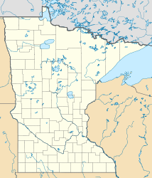
Shady Oak Lake

Shady Oak Lake
Shady Oak Lake

Photo-request.svg

Bild gesucht 

BW

Geographische Lage Minnetonka, Hennepin County, Minnesota, USA
Zuflüsse keine
Abfluss keiner
Daten
Koordinaten 44° 54′ 38″ N, 93° 25′ 54″ W44.9106889-93.4315371276Koordinaten: 44° 54′ 38″ N, 93° 25′ 54″ W
Shady Oak Lake (Minnesota)
Shady Oak Lake
Höhe über Meeresspiegel 276 m
Fläche 53 haf5
Maximale Tiefe 10,7 mf10

Der Shady Oak Lake (auch als Shady Lake bezeichnet[1]) ist ein See in Minnetonka im Hennepin County im US-Bundesstaat Minnesota. Er befindet sich im Osten der Stadt an der Shady Oak Road beziehungsweise 500 Meter östlich des Interstate 494. Die Fläche des Sees mit dem Litoral beträgt 53 Hektar. Die maximale Tiefe beträgt 10,7 Meter.[2][3]

Fischbestand

Im Rahmen einer Fischbestandsaufnahme des Shady Oak Lake von 1991 wurde das Vorhandensein folgender Fischarten festgestellt:[3]

Weblinks

Einzelnachweise

  1. U.S. Geological Survey. Geographic Names Phase I data compilation (1976-1981). 31-Dec-1981. Primarily from U.S. Geological Survey 1:24,000-scale topographic maps (or 1:25K, Puerto Rico 1:20K) and from U.S. Board on Geographic Names files. In some instances, from 1:62,500 scale or 1:250,000 scale maps
  2. Shady Oak Lake im Geographic Names Information System des United States Geological Survey
  3. a b Lake information report: Minnesota DNR

Wikimedia Foundation.

Игры ⚽ Поможем написать реферат

Schlagen Sie auch in anderen Wörterbüchern nach:

  • Oak Hill, Fairfax County, Virginia — Oak Hill   Unincorporated community   …   Wikipedia

  • Lake George (Anoka County) — Infobox lake lake name = Lake George image lake = caption lake = image bathymetry = LakeGeorge layout.jpg caption bathymetry = map location = Anoka County, Minnesota coords = coord|45|21|25|N|093|20|10|W|type:waterbody… …   Wikipedia

  • Oak Point, Texas —   City   Location of Oak Point in Denton County …   Wikipedia

  • Lake Wissota State Park — Geobox|Protected area name = Lake Wissota State Park category = Wisconsin State Park category iucn = V image caption = Lake Wissota State Park s mix of prairie and forest is situated on the northeast shore of Lake Wissota. country = United States …   Wikipedia

  • Double Oak, Texas —   Town   Location of Double Oak in Denton County …   Wikipedia

  • Liste der Seen der Vereinigten Staaten — Inhaltsverzeichnis 1 Seen nach Gewässerart 1.1 Süßwasserseen 1.2 Salz bzw. Brackwasserseen 1.3 Stauseen …   Deutsch Wikipedia

  • County roads in Pine County, Minnesota — Pine County, Minnesota, United States, maintains a number of county routes. Within Pine County, a County Road (CR) is called a Highway if a sealed road and Road if an improved road. Though some of them are county state aid highways (CSAH), all… …   Wikipedia

  • County roads in Hennepin County, Minnesota — Hennepin County, Minnesota, United States maintains a number of county routes, many of them county state aid highways (CSAH). This includes a number of streets through the city of Minneapolis. Contents 1 CR 1–CR 25 2 CR 26–CR 50 3 CR 51–CR 75 …   Wikipedia

  • List of communities in Ontario — Communities in the province of Ontario, Canada Note: this is an incomplete list of communities, not necessarily organized municipalities. For organized municipalities see list of municipalities in Ontario and for census subdivisions see list of… …   Wikipedia

  • County Road 61 (Hennepin County, Minnesota) — County State Aid Highway 61 Route information Maintained by Hennepin County Transportation Department Length: 24.4 mi (39.3 km) …   Wikipedia

Share the article and excerpts

Direct link
Do a right-click on the link above
and select “Copy Link”