Coulman Island

Coulman Island
Coulman-Insel (Antarktis)
DMS
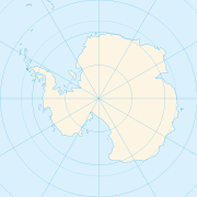
Lage der Coulman-Insel
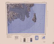
USGS-Karte der Coulman-Insel

Die Coulman-Insel (engl. Coulman Island) ist eine eisbedeckte, vulkanische Insel im Rossmeer der Antarktis. Sie befindet sich vor der Küste der Daniell-Halbinsel im südlichen Teil Viktorialands und besteht aus mehreren miteinander verbundenen Schildvulkanen. Die Insel wird von Kaiserpinguinen, Adeliepinguinen und Robben bewohnt.

Das südliche Ende der Coulman-Insel wird vom Krater Hawkes Heights bestimmt, einer 700 m tiefen, eisgefüllten Caldera von 5 km Durchmesser. Im südwestlichen Bereich der Hawkes Heights liegt der mit 1.998 Metern höchste Punkt der Insel. Die Nordspitze der Insel bildet das Cape Wadworth, wo Kapitän Robert Falcon Scott auf seiner Expedition mit der RRS Discovery am 15. Januar 1902 einen Briefkasten in Form eines an einem 8 m hohen roten Pfahl befestigten Metallzylinders errichtete. Dieser Briefkasten ist heute eine der Historic Sites and Monuments in der Antarktis.[1]

Die Coulman-Insel wurde am 17. Januar 1841 von Kapitän James Clark Ross entdeckt, der von 1840 bis 1843 auf einer Expedition mit der HMS Erebus und in Begleitung der HMS Terror (unter Kapitän Francis Crozier) die Antarktikküste kartierte. Ross benannte die Insel (und das Cape Wadworth) nach dem Onkel seiner Frau Anne, einem Robert John Coulman, Esq. aus Wadworth Hall in Doncaster. Seiner Frau zu Ehren nannte er das Kap im Süden der Insel Cape Anne.

Die Insel liegt innerhalb der Grenzen des von Neuseeland beanspruchten Ross-Nebengebiets. Diese Ansprüche werden jedoch international aufgrund des Antarktisvertrages nicht anerkannt.

Quellen

  1. http://cep.ats.aq/cep/apa/hsm/sites/index.html

Literatur

  • Warren Hamilton (1972): The Hallett Volcanic Province, Antarctica. U.S. Geological Survey Professional Paper 456C, 62 S.
  • H. J. Harrington (1959): Narrative of a visit to the newly discovered Emperor Penguin rookery at Coulman Island, Ross Sea, Antarctica. Notornis, Vol. 8, No. 5, S. 127-132.
  • W. C. McIntosh & P. R. Kyle (1990): A.4. Coulman Island. In: W. E. LeMasurier & J. W. Thomson (Hrsg.), Volcanoes of the Antarctica Plate and Southern Oceans. American Geophysical Union, Antarctica Research Series, Vol. 48, S. 43-45.

-73.5169.757Koordinaten: 73° 30′ S, 169° 45′ O


Wikimedia Foundation.

Игры ⚽ Поможем решить контрольную работу

Schlagen Sie auch in anderen Wörterbüchern nach:

  • Coulman Island — Map showing Coulman Island Geography Location Antarctica Coordinates …   Wikipedia

  • Coulman-Insel — Coulman Island im Februar 1998 Gewässer Rossmeer Geographisch …   Deutsch Wikipedia

  • List of Antarctic and sub-Antarctic islands — This is a List of Antarctic and sub Antarctic islands. Sub Antarctic islands are islands in the Southern Ocean around Antarctica north of the Antarctic Circle (66° 33 38 ). Antarctic islands are the islands in the Southern Ocean or in the seas… …   Wikipedia

  • List of islands of New Zealand — New Zealand consists of a large number of islands. The two main islands, which are much larger than the rest and where most of the population lives, are the North Island and the South Island. The latter is often a little ironically referred to as …   Wikipedia

  • Liste neuseeländischer Inseln — Diese Liste führt die Inseln Neuseelands auf. Neben den zwei Hauptinseln gehören eine Reihe von Inseln in der Hauptkette, Binneninseln und die von Neuseeland teils sehr weit entfernten Outlying Islands zu Neuseeland. Außerdem sind einige… …   Deutsch Wikipedia

  • List of Ultras of Antarctica — This is a list of all the Ultra prominent peaks (with topographic prominence greater than 1,500 metres) in Antarctica. Some islands in the South Atlantic have also been included and can be found at the end of the list. Antarctica Mount Erebus,… …   Wikipedia

  • Liste der höchsten Inseln der Erde — Die Inseln der Erde Die Liste der höchsten Inseln der Erde enthält alle Inseln der Erde mit einer Höhe von größer 1500 m über dem Meer. Bei Inseln im Ozean zählt die Höhe über dem Meeresspiegel, bei Binneninseln die Höhe über dem jeweiligen… …   Deutsch Wikipedia

  • Southern Cross Expedition — The Southern Cross Expedition, officially known as the British Antarctic Expedition 1898 ndash;1900, was the first British venture of the Heroic Age of Antarctic Exploration, and was the forerunner of the much more celebrated expeditions of… …   Wikipedia

  • Список вулканов Антарктики — См. также: Список вулканов мира Список действующих и потухших вулканов Антарктики. Название Высота Местоположение Последнее извержение метров футов Координаты Андрус 2978 9770 75.8, 132.333333 (Mount Andrus) …   Википедия

  • Emperor Penguin — Taxobox name = Emperor Penguin status = LC | status system = IUCN3.1 status ref=IUCN2006|assessors=BirdLife International|year=2004|id=49667|title=Aptenodytes forsteri|downloaded=12 May 2006 Database entry includes justification for why this… …   Wikipedia

Share the article and excerpts

Direct link
Do a right-click on the link above
and select “Copy Link”