- Dawson Road
-
 Dawson Road, 1870
Die Dawson Road war im 19. Jahrhundert ein kanadischer Reise- und Handelsweg zwischen der Thunder Bay und Fort Garry (ab 1873 Winnipeg). Er führte häufig wechselnd über Wasser- und Landwege und bildete den westlichen Teil des Dawson Trail, der Fort Garry mit Toronto verband.
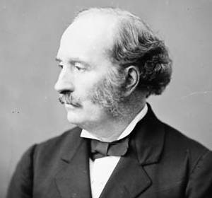
 Simon James Dawson
Die Route wurde 1858 von S. J. Dawson für die kanadische Regierung vermessen und der Bau der Landwege begann 1868. 1870 führte Oberst Garnet Joseph Wolseley seine Truppen über einige der noch nicht vollständig fertiggestellten Wege zur Niederschlagung der Red-River-Rebellion. Nach der Gründung der Provinz Manitoba um Fort Garry als Hauptstadt im gleichen Jahr entwickelte sich die Wirtschaft der Gegend schnell und die Route wurde viel benutzt. Die Mehrzahl vor allem der Warentransporte nutzte aber weiter die deutlich längere Route über Duluth am Oberen See und den Red River, da die Dawson Road mit über 30 Wechseln zwischen Wasser- und Landweg großen Zeitaufwand durch Umladen von Transportgut verursachte. Nach dem Bau der Canadian Pacific Railway, die 1882 schon drei Jahre vor Fertigstellung der Gesamtstrecke die Thunder Bay mit Winnipeg (dem früheren Fort Garry) verband, wurde die Dawson Road kaum noch benutzt und die Wege verfielen.
Weblinks
- Artikel Dawson Road in der Canadian Encyclopedia: englisch, französisch
- S. J. Dawson. In: Dictionary of Canadian Biography. Toronto 1979 ff., ISBN 0-8020-3142-0 (englisch, französisch)
Kategorien:- Früherer Handelsweg
- Geschichte Kanadas

Wikimedia Foundation.