- Filipporiff
-
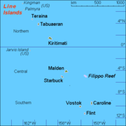 Karte der Line Islands, das Filippo-Riff ist rechts abgebildet
Das Filippo-Riff (engl. Filippo Reef) ist ein Korallenriff, welches etwa 450 Kilometer östlich von Starbuck Island liegt, und zu den Zentralpolynesischen Sporaden zählt.
Die genauen Koordinaten sind 05°30′ S, 151°50′ W. Das Riff liegt in einem recht flachem Wasser. Die Wassertiefe wird auf nur 0,6 m bis 0,9 m geschätzt. Das Riff hat einen Durchmesser (von Nordwest nach Südost) von 1,6 km. Es wurde von der Besatzung der italienischen Bark Filippo am 28. Juni 1886 entdeckt und nach dieser benannt.
-5.5-151.83333333333Koordinaten: 5° 30′ S, 151° 50′ W
Gilbertinseln: Abaiang | Abemama | Aranuka | Arorae | Beru | Butaritari | Kuria | Maiana | Makin | Marakei | Nikunau | Nonouti | Onotoa | Tabiteuea | Tamana | Tarawa
Line Islands: Caroline | Flint | Kiritimati | Malden | Starbuck | Tabuarean | Teraina | Vostok
Phoenixinseln: Birnie | Enderbury | Kanton | McKean | Manra | Nikumaroro | Orona | Rawaki
weitere Insel: Banaba
Inseln und Atolle der Line IslandsNordgruppe: Kingmanriff | Kiritimati | Palmyra-Atoll | Tabuaeran | Teraina
Zentralgruppe: Jarvis | Malden | Starbuck | (Filipporiff)
Südgruppe: Caroline-Atoll | Flint | Vostok

Wikimedia Foundation.