- Alatna River
-
Alatna River 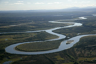
Mündung des Alatna in den Yukon
Daten Lage Alaska (Interior) Flusssystem Yukon River Quelle Gaedake Lake, Endicott Mountains
67° 55′ 17″ N, 155° 1′ 14″ W67.92138-155.020556Mündung Koyukuk River 66.57-152.625Koordinaten: 66° 34′ 12″ N, 152° 37′ 30″ W
66° 34′ 12″ N, 152° 37′ 30″ W66.57-152.625Linke Nebenflüsse Unakserak River, Iniakuk River Durchflossene Seen Circle Lake, Takahula Lake Der Alatna River ist ein etwa 300 km langer Fluss im US-amerikanischen Bundesstaat Alaska.
Der Alatna entspringt als kleines Rinnsal aus dem Geadake Lake in den Endicott Mountains im Herzen der Brooks Range im Gates-of-the-Arctic-Nationalpark, etwa 100 km nördlich des Polarkreises. Er fließt in südöstlicher Richtung und mündet bei Allakaket am Polarkreis in den Koyukuk River.
Die oberen 133 km des Alatna haben den Status eines schützenswerten National Wild and Scenic Rivers im Sinne der Alaska National Interest Lands Conservation Act . Dieser Flussabschnitt wird auch „Alatna Wild River“ genannt und vom National Park Service verwaltet.
Der ab dem Circle Lake ruhig fließende Alatna ist ein beliebter Fluss für Kanuten. Der Circle Lake und der Takahula Lake sind mit dem Wasserflugzeug erreichbar. Ausgebootet wird meist in Allakaket, 135 km flussabwärts des Circle Lake und 120 km flussabwärts des Takahula Lakes.
Weblinks
- Alatna River im Geographic Names Information System des United States Geological Survey
- Alatna Wild and Scenic River
- Gates Of The Arctic National Park and Preserve

Alagnak | Alatna | Andreafsky | Aniakchak | Beaver Creek | Birch Creek | Charley | Chilikadrotna | Delta | Fortymile | Gulkana | Ivishak | John | Kobuk | Koyukuk | Mulchatna | Noatak | Nonvianuk | Nowitna | Salmon | Selawik | Sheenjek | Tinayguk | Tlikakila | Unalakleet | Wind
Wikimedia Foundation.
Schlagen Sie auch in anderen Wörterbüchern nach:
Alatna River — The Alatna River is a federally designated wild and scenic river partially contained within the boundaries of Gates of the Arctic National Park, Alaska. It is called one of the most beautiful rivers in America. The Alatna River stems from the… … Wikipedia
Alatna — steht für: Alatna River, Fluss in den USA Alatna (Alaska), Stadt in Alaska Alatna Hills, Gebirgszug in Alaska Alatna (AOG 81), Schiff Alatna (Roman), Roman von Hans Otto Meissner Diese Seite ist eine Begriffsklärung zur … Deutsch Wikipedia
Alatna, Alaska — Infobox Settlement official name = Alatna, Alaska settlement type = CDP nickname = motto = imagesize = image caption = image map caption = Location of Alatna, Alaska mapsize = 250x200px mapsize1 = map caption1 = subdivision type = Country… … Wikipedia
Alatna (rivière) — 67°15′00″N 153°33′00″O / 67.25, 153.55 … Wikipédia en Français
Wind River (Alaska) — Vorlage:Infobox Fluss/BILD fehltVorlage:Infobox Fluss/DGWK fehltVorlage:Infobox Fluss/QUELLHÖHE fehltVorlage:Infobox Fluss/MÜNDUNGSHÖHE fehltVorlage:Infobox Fluss/HÖHENUNTERSCHIED fehltVorlage:Infobox Fluss/EINZUGSGEBIET fehltVorlage:Infobox… … Deutsch Wikipedia
Yukon River — Infobox River | river name = Yukon River caption = A view of the Yukon River near Dawson City, Yukon origin = Atlin and Tagish Lakes mouth = Bering Sea basin countries = United States, Canada length = 3,700 km (2,300 mi) elevation = discharge = 6 … Wikipedia
Koyukuk River — River, central Alaska, U.S. It rises on the southern slope of the Brooks Range and flows southwest for 500 mi (800 km) to join the Yukon River, of which it is a major tributary. It was named for the Koyukon, a local Indian people. * * * ▪ river,… … Universalium
Koyukuk River — Der Koyukuk River aus der LuftVorlage:Infobox Fluss/KARTE fehlt Daten … Deutsch Wikipedia
Kobuk River — The Kobuk River is approximately convert|280|mi|km|0|lk=on long, located in the Arctic region of northwestern Alaska in the United States. [USGS Geographic Names Information System (GNIS). [http://geonames.usgs.gov/pls/gnispublic/f?p=gnispq:3:::NO… … Wikipedia
Kobuk River — bei KianaVorlage:Infobox Fluss/KARTE fehlt Daten … Deutsch Wikipedia
Alatna River

18+
© Academic, 2000-2024
- Kontaktieren Sie uns: Unterstützung, Werbung
Wörterbücher Export, schritte mit PHP, Joomla, Drupal, WordPress, MODx.