- Maimbung
-
Municipality of Maimbung Lage von Maimbung in der Provinz Sulu 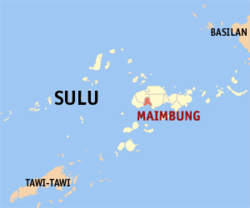
Basisdaten Bezirk: Autonomous Region in Muslim Mindanao Provinz: Sulu Barangays: 27 Distrikt: 1. Distrikt von Sulu PSGC: 156605000 Einkommensklasse: 5. Einkommensklasse Haushalte: 3920 Zensus 1. Mai 2000Einwohnerzahl: 38.092 Zensus 1. August 2007Koordinaten: 5° 56′ N, 121° 2′ O5.9333333333333121.03333333333Koordinaten: 5° 56′ N, 121° 2′ O Postleitzahl: 7409 Offizielle Webpräsenz: Maimbung Geographische Lage auf den Philippinen 

Maimbung Maimbung ist eine philippinische Stadtgemeinde in der Provinz Sulu. Nach dem Zensus vom 1. Mai 2000 hat sie 24.982 Einwohner in 3920 Haushalten.
Baranggays
Maimbung ist politisch in 27 Baranggays unterteilt.
- Anak Jati
- Bato Ugis
- Bualo Lahi
- Bualo Lipid
- Bulabog
- Duhol Kabbon
- Gulangan
- Ipil
- Kandang
- Kapok-Punggol
- Kulasi
- Labah
- Lagasan Asibih
- Lantong
- Lapa
- Laud Kulasi
- Laum Maimbung
- Lower Tambaking
- Lunggang
- Matatal
- Patao
- Poblacion (Maimbung)
- Ratag Limbon
- Tabu-Bato
- Tandu Patong
- Tubig-Samin
- Upper Tambaking
Stadtgemeinden in der Provinz SuluStadtgemeinden: Hadji Panglima Tahil | Indanan | Jolo | Kalingalan Caluang | Lugus | Luuk | Maimbung | Old Panamao | Omar | Pandami | Panglima Estino | Pangutaran | Parang | Pata | Patikul | Siasi | Talipao | Tapul | Tongkil
Wikimedia Foundation.
Schlagen Sie auch in anderen Wörterbüchern nach:
Maimbung — Original name in latin Maimbung Name in other language Maibun, Maimbung State code PH Continent/City Asia/Manila longitude 5.9272 latitude 121.02935 altitude 4 Population 3779 Date 2011 07 31 … Cities with a population over 1000 database
Maimbung, Sulu — Maimbung is a 5th class municipality in the province of Sulu, Philippines. According to the 2000 census, it has a population of 24,982 people in 3,920 households. Barangays Maimbung is politically subdivided into 27 barangays. And Sultan as an… … Wikipedia
PH-SLU — Lage der Inselprovinz Sulu Sulu ist eine Provinz der Philippinen. Sie besteht aus mehreren Inseln des Sulu Archipels und nimmt den äußersten Südwesten des Inselstaates zwischen Basilan und Tawi Tawi ein. Die Provinz gehört politisch dem Bezirk… … Deutsch Wikipedia
Sulu Archipelago — Infobox Islands name = Sulu Archipelago image caption = Map of the Philippines; the bottom left shows the location of the Visayas native name = Sulu native name link = Tausug language location = South East Asia archipelago = Philippines area =… … Wikipedia
Jolo — Infobox Islands name = Jolo image caption = Map of Sulu showing the location of Jolo locator Location map|Philippines|lat=5.983333|long=121.133333|width=175|float=center map custom = yes native name = Sulu native name link = location = South East … Wikipedia
Old Panamao, Sulu — Old Panamao is a 4th class municipality in the province of Sulu, Philippines. According to the 2007 census, it has a population of 49,903 people in 5,663 households. Barangays Old Panamao is politically subdivided into 31 barangays. Asin Bakud… … Wikipedia
List of cities and municipalities in the Philippines — This is a list of cities and municipalities in the Philippines arranged by province and in alphabetical order. As of 2006, there are 118 cities and 1509 municipalities.As of September 4, 2007, there are 136 cities, 1,495 municipalities, 81… … Wikipedia
List of ZIP Codes in the Philippines — In the Philippines, the Philippine ZIP code is used by the Philippine Postal Corporation (Philpost) to simplify the distribution of mail. While in function it is similar to the ZIP code used in the United States, its form and its usage is quite… … Wikipedia
Legislative districts of Sulu — Philippines This article is part of the series: Politics and government of the Philippines … Wikipedia
Jamalul Kiram III — Jamalul D. Kiram III is the current Sultan of Sulu in Sulu, southern Philippines. He was a candidate for senator in the 2007 Philippine Elections.Born on July 16, 1938 in Maimbung, Sulu, he is the eldest son of the late Sultan Punjungan Kiram and … Wikipedia
Maimbung


18+
© Academic, 2000-2024
- Kontaktieren Sie uns: Unterstützung, Werbung
Wörterbücher Export, schritte mit PHP, Joomla, Drupal, WordPress, MODx.