- Malapatan
-
Municipality of Malapatan Lage von Malapatan in der Provinz Sarangani 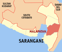
Basisdaten Bezirk: SOCCSKSARGEN Provinz: Sarangani Barangays: 12 Distrikt: 1. Distrikt von Sarangani PSGC: 128006000 Einkommensklasse: 1. Einkommensklasse Haushalte: 10.208 Zensus 1. Mai 2000Einwohnerzahl: 65.605 Zensus 1. August 2007Bevölkerungsdichte: 105 Einwohner je km² Fläche: 624,56 km² Koordinaten: 5° 58′ N, 125° 17′ O5.9666666666667125.28333333333Koordinaten: 5° 58′ N, 125° 17′ O Postleitzahl: 9516 Bürgermeister: Aida C. Singcoy Offizielle Webpräsenz: Malapatan Geographische Lage auf den Philippinen 

Malapatan Malapatan ist eine philippinische Stadtgemeinde in der Provinz Sarangani.
Die Mehrheit der Einwohner sind vom Ursprung her Ilonggos.
Geografie
Malapatan liegt östlich der Bucht von Sarangani. Die Stadtgemeinde grenzt im Osten an die Provinz Davao del Sur, im Norden an Alabel und im Süden an Glan.
Baranggays
Malapatan ist politisch in zwölf Baranggays unterteilt.
- Daan Suyan
- Kihan
- Kinam
- Libi
- Lun Masla
- Lun Padidu
- Patag
- Poblacion (Malapatan)
- Sapu Masla
- Sapu Padidu
- Tuyan
- Upper Suyan
Wirtschaft
Malapatans Wirtschaft basiert zu großen Teilen auf der Landwirtschaft und insbesondere auch auf der Kopragewinnung. Tierhaltung ist die zweitwichtigste Einkommensquelle, insbesondere Rinderhaltung. Andere landwirtschaftliche Erzeugnisse sind Kokosnüsse, Mais, Zuckerrohr, Bananen, Ananas, Mangos, Schweinefleisch, Hühnereier, Rindfleisch und Fisch.
Das Wirtschaftswachstum hat sich im vergangenen Jahrzehnt durch die globalen Kommunikationsmöglichkeiten aufgrund der Fertigstellung eines modernen Highways beschleunigt, wodurch die Handels- und Transportmöglichkeiten stark verbessert wurden.
Schlagen Sie auch in anderen Wörterbüchern nach:
Malapatan — Original name in latin Malapatan Name in other language Malapatan State code PH Continent/City Asia/Manila longitude 5.96917 latitude 125.28944 altitude 26 Population 19439 Date 2012 01 17 … Cities with a population over 1000 database
Malapatan, Sarangani — Malapatan Municipality Map of Sarangani showing the location of Malapatan … Wikipedia
Sarangani — For the municipality in Davao del Sur, see Sarangani, Davao del Sur. Sarangani Province … Wikipedia
Alabel — Municipality of Alabel Lage von Alabel in der Provinz Sarangani Basisdaten Bezirk … Deutsch Wikipedia
PH-SAR — Dieser Artikel beschreibt die Provinz Sarangani auf den Philippinen; zu anderen Bedeutungen siehe Sarangani (Begriffsklärung). Lage der Provinz Sarangani Sarangani ist eine Provinz der Philippinen und am südlichen Ende des Kernlandes der Insel… … Deutsch Wikipedia
General Santos City — Infobox Settlement official name = General Santos City other name = native name = Lungsod ng Heneral Santos Dakbayan sa Heneral Santos nickname = Tuna Capital of the Philippines, Boom Town City of the South settlement type = motto = Go GenSan!… … Wikipedia
Maitum, Sarangani — Maitum Municipality Seal … Wikipedia
Malungon, Sarangani — Malungon Municipality Map of Sarangani showing the location of Malungon … Wikipedia
List of cities and municipalities in the Philippines — This is a list of cities and municipalities in the Philippines arranged by province and in alphabetical order. As of 2006, there are 118 cities and 1509 municipalities.As of September 4, 2007, there are 136 cities, 1,495 municipalities, 81… … Wikipedia
List of ZIP Codes in the Philippines — In the Philippines, the Philippine ZIP code is used by the Philippine Postal Corporation (Philpost) to simplify the distribution of mail. While in function it is similar to the ZIP code used in the United States, its form and its usage is quite… … Wikipedia
Malapatan


18+
© Academic, 2000-2024
- Kontaktieren Sie uns: Unterstützung, Werbung
Wörterbücher Export, schritte mit PHP, Joomla, Drupal, WordPress, MODx.