- Malilipot
-
Municipality of Malilipot Lage von Malilipot in der Provinz Albay 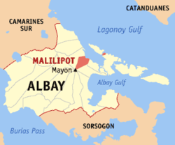
Basisdaten Bezirk: Bicol-Region Provinz: Albay Barangays: 18 Distrikt: 1. Distrikt von Albay PSGC: 050509000 Einkommensklasse: 4. Einkommensklasse Haushalte: 5714 Zensus 1. Mai 2000Einwohnerzahl: 33.593 Zensus 1. August 2007Koordinaten: 13° 19′ N, 123° 44′ O13.316666666667123.73333333333Koordinaten: 13° 19′ N, 123° 44′ O Postleitzahl: 4510 Geographische Lage auf den Philippinen 

Malilipot Malilipot ist eine philippinische Stadtgemeinde in der Provinz Albay. Sie hat 29.541 Einwohner in 5714 Haushalten (Zensus 1. Mai 2000).
Baranggays
Malilipot ist politisch unterteilt in 18 Baranggays.
- Binitayan
- Calbayog
- Canaway
- Barangay I (Pob.)
- Barangay II (Pob.)
- Barangay III (Pob.)
- Barangay IV (Pob.)
- Barangay V (Pob.)
- Salvacion
- San Antonio Santicon (Pob.)
- San Antonio Sulong
- San Francisco
- San Isidro Ilawod
- San Isidro Iraya
- San Jose
- San Roque
- Santa Cruz
- Santa Teresa
Schlagen Sie auch in anderen Wörterbüchern nach:
Malilipot — 13°19′N 123°44′E / 13.317, 123.733 … Wikipédia en Français
Malilipot — Original name in latin Malilipot Name in other language Malilipot State code PH Continent/City Asia/Manila longitude 13.3188 latitude 123.7385 altitude 14 Population 33593 Date 2011 08 20 … Cities with a population over 1000 database
Malilipot (Albay) — Malilipot Carte d Albay avec localisation de Malilipot Malilipot est une municipalité de la province d Albay, aux Philippines. Villes et municipalités d … Wikipédia en Français
Malilipot, Albay — Map of Albay showing the location of Malilipot Malilipot is a 4th class municipality in the province of Albay, Philippines. According to the 2007 census, it has a population of 33,593 people in 5,714 households. Contents … Wikipedia
Tabaco City — For the narcotic, see tobacco. Infobox Philippine city infoboxtitle = City of Tabaco sealfile = locatormapfile = Ph locator albay tabaco.png caption = Map of Albay showing the location of Tabaco City. region = Bicol Region (Region V) province =… … Wikipedia
Ligao — City of Ligao Lungsod ng Ligao Lage von Ligao in der Provinz Albay Basisdaten Bezirk: Bicol Region … Deutsch Wikipedia
PH-ALB — Lage der Provinz Albay Albay ist eine eine Provinz der Philippinen. Sie befindet sich im Süden der Insel Luzon auf der Bicol Halbinsel und gehört politisch dem Bezirk Bicol Region (Region V) an. Ihre Hauptstadt ist Legazpi City, der Gouverneur… … Deutsch Wikipedia
Tabaco City — City of Tabaco Lage von Tabaco in der Provinz Albay Basisdaten Bezirk: Bicol Region … Deutsch Wikipedia
Geography of the Philippines — Country geography name = the Philippines continent = Asia region = Southeast Asia coordinates = 13°00 N 122°00 E area ranking = 72nd km area = 300000 percent land = 99.38 km coastline = 36289 borders = None northernmost point = Y Ami island… … Wikipedia
Mayon Volcano — as viewed from Ligñon Hill in Legazpi City, Albay in December 2006 Elevation … Wikipedia
Malilipot


18+
© Academic, 2000-2024
- Kontaktieren Sie uns: Unterstützung, Werbung
Wörterbücher Export, schritte mit PHP, Joomla, Drupal, WordPress, MODx.