- Marihatag
-
Municipality of Marihatag Lage von Marihatag in der Provinz Surigao del Sur 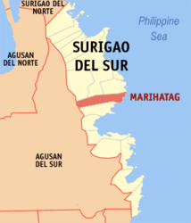
Basisdaten Bezirk: Caraga Provinz: Surigao del Sur Barangays: 12 Distrikt: 1. Distrikt von Surigao del Sur PSGC: 166814000 Einkommensklasse: 4. Einkommensklasse Haushalte: 2857 Zensus 1. Mai 2000Einwohnerzahl: 17.622 Zensus 1. August 2007Koordinaten: 8° 48′ N, 126° 18′ O8.8126.3Koordinaten: 8° 48′ N, 126° 18′ O Postleitzahl: 8306 Bürgermeister: Tito C. Pascual Offizielle Webpräsenz: Marihatag Geographische Lage auf den Philippinen 

Marihatag Marihatag ist eine philippinische Stadtgemeinde in der Provinz Surigao del Sur. Nach dem Zensus vom 1. Mai 2000 hat sie 16.394 Einwohner in 2857 Haushalten.
Baranggays
Marihatag ist politisch in zwölf Baranggays unterteilt.
- Alegria
- Amontay
- Antipolo
- Arorogan
- Bayan
- Mahaba
- Mararag
- Poblacion
- San Antonio
- San Isidro
- San Pedro
- Santa Cruz
Städte und Stadtgemeinden in der Provinz Surigao del SurStädte: Bislig City | Tandag City
Stadtgemeinden: Barobo | Bayabas | Cagwait | Cantilan | Carmen | Carrascal | Cortes | Hinatuan | Lanuza | Lianga | Lingig | Madrid | Marihatag | San Agustin | San Miguel | Tagbina | Tago (Surigao del Sur)
Wikimedia Foundation.
Schlagen Sie auch in anderen Wörterbüchern nach:
Marihatag — Original name in latin Marihatag Name in other language Marihatag State code PH Continent/City Asia/Manila longitude 8.8059 latitude 126.2966 altitude 7 Population 3829 Date 2012 09 06 … Cities with a population over 1000 database
Marihatag, Surigao del Sur — Map of Surigao del Sur showing the location of Marihatag Marihatag is a 4th class municipality in the province of Surigao del Sur, Philippines. According to the 2000 census, it has a population of 16,394 people in 2,857 households. The current… … Wikipedia
Cagwait — Municipality of Cagwait Lage von Cagwait in der Provinz Surigao del Sur Basisdaten Bezirk … Deutsch Wikipedia
PH-SUR — Lage der Provinz Surigao del Sur Surigao del Sur ist die 56. Provinz des Inselstaates der Philippinen. Sie befindet sich an der nordöstlichen Küste der Insel Mindanao und gehört politisch dem Regierungsbezirk Caraga (Region XIII) an. Der Sitz der … Deutsch Wikipedia
Surigao del Sur — Infobox Philippine province name = Surigao del Sur sealfile = Ph seal surigao del sur.png region = Caraga (Region XIII) capital = Tandag City founded = pop2000 = 501,808 pop2000rank = 49th largest popden2000 = 110 popden2000rank = 15th lowest… … Wikipedia
Kamayo language — Kamayo is a minor language spoken in the area of Bislig City and also in San Agustin and Marihatag, Surigao del Sur, in the Southern Philippines. It has 7,565 speakers (2000, WCD). The dialect known as kamayo varies from one municipality to… … Wikipedia
Cagwait, Surigao del Sur — Cagwait is a 4th class municipality in the province of Surigao del Sur, Philippines. According to the 2000 census, it has a population of 18,577 people in 3,406 households.BarangaysCagwait is politically subdivided into 11 barangays.* Aras Asan * … Wikipedia
Cortes, Surigao del Sur — Map of Surigao del Sur showing the location of Cortes Cortes is a 4th class municipality in the province of Surigao del Sur, Philippines. According to the 2000 Philippine census, it has a population of 14,825 people in 2,742 households. Contents … Wikipedia
Madrid, Surigao del Sur — Map of Surigao del Sur showing the location of Madrid Madrid is a 4th class municipality in the province of Surigao del Sur, Philippines. Madrid was named after the capital city of Spain, Madrid. It has 14 barangay s and two comprising the… … Wikipedia
Tago, Surigao del Sur — Fact and FiguresGeographical LocationTago is located in the central part of Surigao del Sur facing the Pacific Ocean. It lies between 126 degrees 12 minutes longitude and 9 degrees minutes north latitude. It is bounded on the north by the Capital … Wikipedia
Marihatag


18+
© Academic, 2000-2024
- Kontaktieren Sie uns: Unterstützung, Werbung
Wörterbücher Export, schritte mit PHP, Joomla, Drupal, WordPress, MODx.