- Mejit
-
Mejit NASA-Bild von Mejit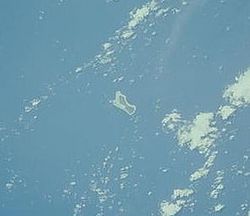
Gewässer Pazifischer Ozean Inselgruppe Marshall-Inseln Geographische Lage 10° 17′ 4″ N, 170° 52′ 13″ O10.284444444444170.87027777778Koordinaten: 10° 17′ 4″ N, 170° 52′ 13″ O 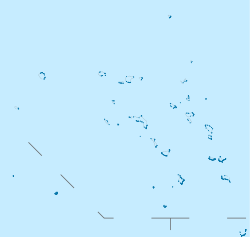

Länge 3,5 km Breite 750 m Fläche 1,86 km² Einwohner 445 (1988)
239 Einw./km²Mejit (deutsch veraltet: Neujahrsinseln[1]) ist ein gehobenes Atoll der Ratak-Kette der Marshallinseln. Das ehemalige Atoll hat eine Landfläche von 1,86 km², die Lagune ist ausgetrocknet. Das nächste (echte) Atoll, Ailuk, liegt 85 km in westlicher Richtung entfernt
Die Bewohner der Insel bauen Brotfrüchte und Taro an. Des Weiteren flechten sie weithin bekannte Matten aus den schilfartigen Blättern des Schraubenbaumes. Besonderheiten der Insel sind ein für die Region einzigartiger Süßwassersee mit Enten und die Stromversorgung der Bewohner durch eine Solaranlage.
Die Insel verfügt über eine 900 Meter lange Start- und Landebahn für Kleinflugzeuge (IATA-Code:MJB), welche fast ausschließlich von Air Marshall Islands angeflogen wird.
Einzelnachweise
- ↑ Deutsches Koloniallexikon. Hrsg. von Heinrich Schnee. - Leipzig: Quelle & Meyer 1920. - 3 Bde
Weblinks
- Bild und Kurzbeschreibung(engl.)
- Installation der Solarzellenanlage (engl.)
- Geographische Informationen (engl.)
 Atolle und Einzel-Inseln der Marshallinseln
Ratak-Kette: Ailuk | Arno-Atoll | Aur | Bikar | Bokak | Erikub | Knox-Atoll | Likiep | Majuro-Atoll | Maloelap | Mili | Toke | Utirik | Wotje
Keinem Atoll zugehörige Inseln: Jemo | Mejit
Ralik-Kette: Ailinginae | Ailinglapalap | Bikini-Atoll | Ebon-Atoll | Eniwetok | Jaluit | Kwajalein | Lae-Atoll | Namorik | Namu | Rongdrik | Rongelap-Atoll | Ujae | Ujelang | Wotho
Keinem Atoll zugehörige Inseln: Jabwot | Kili | Lib
Wikimedia Foundation.
Schlagen Sie auch in anderen Wörterbüchern nach:
Mejit — is one of the few islands (rather than atolls) in the Republic of the Marshall Islands. With an estimated population of 400 people, the island is lush in pandanus, breadfruit and taro. It has a beautiful fresh water lake (rare in the Marshall… … Wikipedia
Mejit — Mejit, eine der Marshallinseln (s. d.) … Meyers Großes Konversations-Lexikon
mejit — mèjit m DEFINICIJA reg. ekspr. mrtvo tijelo; mrtvac ETIMOLOGIJA tur. meyyit ← arap. mäyyit … Hrvatski jezični portal
Mejit — 10°17′N 170°53′E / 10.283, 170.883 Mejit est une île des Marshall, habitée par environ 300 personnes … Wikipédia en Français
Mejit — Imagen satelital de la NASA del Atolón Mejit. Mejit es un atolón de la cadena de Ratak de las Islas Marshall. El antiguo atolón tiene una superficie de tan solo 1.86 kilómetros cuadrados, la laguna del mismo se ha secado. El siguiente (verdadero) … Wikipedia Español
Mejit — Original name in latin Mejit Name in other language State code MH Continent/City Pacific/Majuro longitude 10.27531 latitude 170.86461 altitude 13 Population 0 Date 2010 08 06 … Cities with a population over 1000 database
Mejit Island — NASA picture of Mejit Island … Wikipedia
Mejit Airport — IATA: MJB – ICAO: none – FAA LID: Q30 Summary Serves Mejit Island, Marshall Islands Elevation AMSL 5 f … Wikipedia
Mejit Island — Admin ASC 1 Code Orig. name Mejit Island Country and Admin Code MH.310 MH … World countries Adminstrative division ASC I-II
MJB — Mejit Island, Marshall Islands (Regional » Airport Codes) … Abbreviations dictionary
Mejit


18+
© Academic, 2000-2024
- Kontaktieren Sie uns: Unterstützung, Werbung
Wörterbücher Export, schritte mit PHP, Joomla, Drupal, WordPress, MODx.