- Miura (Kanagawa)
-
Miura-shi
三浦市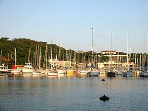
Geographische Lage in Japan 

Region: Kantō Präfektur: Kanagawa Koordinaten: 35° 9′ N, 139° 37′ O35.144166666667139.62083333333Koordinaten: 35° 8′ 39″ N, 139° 37′ 15″ O Basisdaten Fläche: 32,28 km² Einwohner: 47.975
(1. Juli 2011)Bevölkerungsdichte: 1.486 Einwohner je km² Gemeindeschlüssel: 14210-7 Symbole Baum: Japanische Schwarzkiefer Blume: Crinum asiaticum Vogel: Japanischer Kormoran Rathaus Adresse: Miura City Hall
1-1, Shiroyama-chō
Miura-shi
Kanagawa 238-0298Webadresse: http://www.city.miura.kanagawa.jp Lage Miuras in der Präfektur Kanagawa 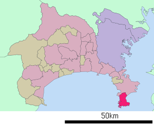
Miura (jap. 三浦市, -shi) ist eine Stadt im Süden der Präfektur Kanagawa. Miura liegt südlich von Tokio und Yokohama auf der Miura-Halbinsel an der Sagami-Bucht und der Bucht von Tokio.
Miura ist bekannt für den Miura-Marathon, der üblicherweise in der ersten Märzwoche abgehalten wird. Das Rennen besteht aus Strecken über 5 km, 10 km und einem Halbmarathon. Durch die vielen Hügel und Steigungen besitzt es einen hohen Schwierigkeitsgrad. Der höchste Punkt des Rennens ist 72 m ü. NN.
Zur Stadt gehört der Hafen von Misaki, der im 18. Jahrhundert der wichtigste Hafen Japans war und heute der zweitwichtigste für Thunfische.
Inhaltsverzeichnis
Sehenswürdigkeiten
 Luftbild von Jōgashima
- Jōgashima (城ヶ島)
- Aburatsubo (油壺)
- Misaki-Gyoko (三崎漁港)
Verkehr
- Zug:
- Keikyu-Hauptlinie, Richtung Shinagawa (Tokio)
- Straße:
Partnerstädte
Angrenzende Städte und Gemeinden
Weblinks
 Commons: Miura – Sammlung von Bildern, Videos und Audiodateien
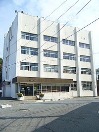 Rathaus von Miura
 Gemeinden und Landkreise in der Präfektur Kanagawa
Kreisfreie Städte (shi): Atsugi | Ayase | Chigasaki | Ebina | Fujisawa | Hadano | Hiratsuka | Isehara | Kamakura | Kawasaki | Minamiashigara | Miura | Odawara | Sagamihara | Yamato | Yokohama (Verwaltungssitz) | Yokosuka | Zama | Zushi
Aikō-gun: Aikawa | Kiyokawa | Ashigarakami-gun: Kaisei | Matsuda | Nakai | Ōi | Yamakita | Ashigarashimo-gun: Hakone | Manazuru | Yugawara | Kōza-gun: Samukawa | Miura-gun: Hayama | Naka-gun: Ninomiya | Ōiso
Wikimedia Foundation.
Schlagen Sie auch in anderen Wörterbüchern nach:
Miura, Kanagawa — Miura 三浦市 city 三浦市 • Miura shi … Wikipedia
Miura — Family name Pronunciation Miura Region of origin Japanese Footnotes: [1] Miura can mean … Wikipedia
Miura — bezeichnet : eine italienische Band: Miura (Band) einen Sportwagen: Lamborghini Miura einen ehemaligen brasilianischen Sportwagenhersteller: Miura (Auto) eine Halbinsel in Japan: Miura Halbinsel eine Stadt auf dieser Halbinsel: Miura… … Deutsch Wikipedia
Miura (Halbinsel) — Lage der Halbinsel Landsat Foto aus hochauflösenden Daten des Space Shuttle. Die Halbinsel Miura ( … Deutsch Wikipedia
Miura-Kaigan Station — is a railway station located in Miura, Kanagawa Prefecture, Japan.LinesMiura Kaigan Station is served by the following line:*Keihin Electric Express Railway **Keikyū Kurihama Linetation layoutKeikyū platforms.Adjacent… … Wikipedia
Kanagawa Prefectural Board of Education — (神奈川県教育委員会) is the board of education of the Kanagawa Prefecture, Japan.The board consists of six members; one of them is elected as the chair (教育委員長), and one of them is appointed by the board as the superintendent (教育長).The board administers to … Wikipedia
Miura-Halbinsel — Landsat Foto aus hochauflösenden Daten des Space Shuttle Gewässer 1 Bucht von Tokio … Deutsch Wikipedia
Miura — puede referirse a: Miura, una ganadería de toros de lidia. Miura, un apellido japonés; o Mihura, un apellido español. Miura, una ciudad en Kanagawa (Japón). Kazuyoshi Miura, futbolista profesional japonés. Miura, un modelo de coche superdeportivo … Wikipedia Español
Kanagawa's 11th district — is a constituency of the House of Representatives in the Diet of Japan (national legislature). It is located in Kanagawa Prefecture, and consists of the cities of Miura and Yokosuka. Former Prime Minister Junichiro Koizumi has served as the first … Wikipedia
Miura District, Kanagawa — Map of Miura District with Meiji period area in yellow, modern area in green Miura District (三浦郡, Miura gun?) is an administrative district … Wikipedia
Miura (Kanagawa)


18+
© Academic, 2000-2024
- Kontaktieren Sie uns: Unterstützung, Werbung
Wörterbücher Export, schritte mit PHP, Joomla, Drupal, WordPress, MODx.