Arnhem Land Aboriginal Reserve
- Arnhem Land Aboriginal Reserve
-

Arnhemland
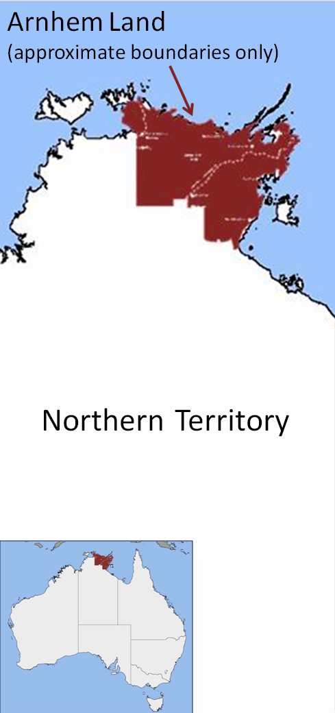
Das Arnhemland im Northern Territory (Australien) ist ein Siedlungsgebiet der Aborigines und mit 97.000 km² etwas größer als Portugal.
Geografie
Arnhemland liegt an der Nordküste des Kontinents, etwa 200 km östlich der Stadt Darwin. Es leben auf diesem großen Raum nur noch knapp 20.000 Menschen.
Das Arnhemland erstreckt sich von Port Roper am Golf von Carpentaria bis zum East Alligator River, wo es an den Kakadu-Nationalpark angrenzt. Das Land wird vom Northern Land Council verwaltet und ist sehr spärlich besiedelt.
Status
Seit die australische Regierung sie 1976 als Eigentümer des Landes anerkannte, leben hier wieder Aborigines. Besucher benötigen eine spezielle Erlaubnis der Aborigines vom Yolngu-Stamm, die bis zu einem Jahr im Voraus beantragt werden muss; bis auf Gunbalanya und den Garig-Gunak-Barlu-Nationalpark ist das Gebiet für Touristen praktisch komplett gesperrt.
Name
Das Land trägt den Namen der niederländischen Stadt Arnheim (Arnhem) nach einem Schiff, auf dem 1623 der niederländische Seefahrer Willem Joosten van Colster die Gegend „entdeckte“. Seinen Namen erhielt es von dem englischen Forschungsreisenden und Kartographen Matthew Flinders.
Weblinks
Wikimedia Foundation.
Schlagen Sie auch in anderen Wörterbüchern nach:
Arnhem Land — /ˈanəm lænd/ (say ahnuhm land) noun 1. a region in the NT, in the north eastern part, made an Aboriginal reserve in 1931, now the Arnhem Land Aboriginal Land Trust; noted prehistoric archaeological and art sites. About 97 000 km2. 2. (formerly)… …
Arnhem Land — Infobox Australian Place | type = region name = Arnhem Land state = nt imagesize = 160 caption = Approximate location of Arnhem Land pop = 16,230 pop footnotes=(2007) [cite news|url=http://www.ausstats.abs.gov.au/ausstats/subscriber.nsf/0/6C2E0D5E… … Wikipedia
Arnhem Land — /ahr neuhm/ a region in N Northern Territory, Australia: site of Aborigine reservation. Also, Arnhemland. * * * Region, northeastern Northern Territory, Australia. It extends south from Van Diemen Gulf to the Gulf of Carpentaria and Groote… … Universalium
Aboriginal reserve — /æbəˌrɪdʒənəl rəˈzɜv/ (say abuh.rijuhnuhl ruh zerv) noun (in Australia) a reserve (def. 12) formerly put aside for habitation by Aboriginal people. From the 1860s, Acts were passed in each of the colonies providing for proclamation of areas… …
Northern Land Council — The Northern Land Council (NLC) is in the Top End of the Northern Territory of Australia. It has its origins in the struggle of Australian Aboriginal people for rights to fair wages and land. This included the strike and walk off by the Gurindji… … Wikipedia
Gove land rights case — In December 1968, the Yolngu people living in Yirrkala, who were the traditional owners of the Gove Peninsula in Arnhem Land, obtained writs in the Supreme Court of the Northern Territory against the Nabalco Corporation, which had secured a… … Wikipedia
Gove Peninsula — Infobox Australian Place | type = region name = Gove and Arnhem Land state = nt caption = The Gove Peninsula (coord|12|17|S|136|49|E|region:AU NT) is at the northeastern corner of Arnhem Land in the Northern Territory of Australia. The peninsula… … Wikipedia
Groote Eylandt — Infobox Islands name = Groote Eylandt image caption = Groote Eylandt from space, November 1989 image size = locator Location map|Australia|lat= 14|long=136.53 map custom = yes native name = native name link = nickname = location = Gulf of… … Wikipedia
Galiwinku — ▪ island, Northern Territory, Australia formerly Elcho Island, island in the Arafura Sea, 2 miles (3 km) across Cadell Strait from Napier Peninsula, a part of Northern Territory, Australia, and of the Arnhem Land Aboriginal Reserve. It… … Universalium
Goulburn Islands — ▪ islands, Australia group of islands in the Arafura Sea off the northern coast of Arnhem Land in Northern Territory, northern Australia. They comprise South Goulburn Island (30 square miles [78 square km]), lying 2 miles (3 km) offshore… … Universalium