Nea Erythraia

Nea Erythraia
Gemeinde Nea Erythrea
Δήμος Νέας Ερυθραίας (Νέα Ερυθραία)
Nea Erythrea (Griechenland)
DEC
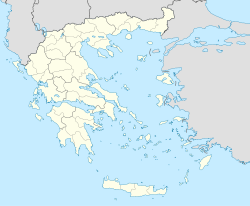
Basisdaten
Staat: Griechenland
Verwaltungsregion: Attika
Präfekturbezirk: Athen
Geographische Koordinaten: 38° 6′ N, 23° 49′ O38.10133333333323.8210277777787Koordinaten: 38° 6′ N, 23° 49′ O
Höhe ü. d. M.: 310 m
(Durchschnitt)
Fläche: 4,831 km²
Einwohner: 15.439 (2001[1])
Bevölkerungsdichte: 3.195,8 Ew./km²
Gemeindelogo:
Gemeindelogo von Gemeinde Nea Erythrea}}}
Sitz: Nea Erythrea
LAU-1-Code-Nr.: A12800
Gemeindegliederung: 1 Gemeindebezirk
Website: www.neaerythraia.com
Lage im Präfekturbezirk Athen
Bild:Dimos Neas Erythreas.png

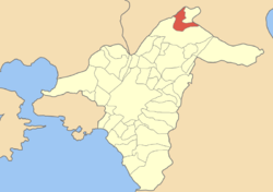
Nea Erythrea (griechisch Νέα Ερυθραία (f. sg.)) ist eine Gemeinde und Stadt im Nordosten des Präfekturbezirks Athen der Verwaltungsregion Attika in Griechenland. Die Gemeinde hat eine Bevölkerung von 15.439 Einwohnern (2001).

1981 lag die Einwohnerzahl noch bei 10.100, 1991 betrug sie bereits 12.993.

Einzelnachweise

  1. Informationen des griechischen Innenministeriums

Wikimedia Foundation.

Игры ⚽ Нужна курсовая?

Schlagen Sie auch in anderen Wörterbüchern nach:

  • Nea Erythraia — Νέα Ερυθραία Location …   Wikipedia

  • Nea Erythraia — Original name in latin Na Erythraa Name in other language Nea Erithraia, Nea Erythraia, Na Erithraa, Na Erythraa State code GR Continent/City Europe/Athens longitude 38.1 latitude 23.81667 altitude 274 Population 16432 Date 2012 02 28 …   Cities with a population over 1000 database

  • Kifissia — Infobox Greek Dimos name = Kifissia name local = Κηφισιά caption skyline = The Villa Atlantis the work of architect Ernst Ziller (1837 1923) city city lat deg = 38 lat min = 5 lon deg = 23 lon min = 49 elevation min = elevation = 290 elevation… …   Wikipedia

  • Lavriou Square-Strofyli railway line — The Lavriou Square Strofyli Railroad Line (Greek: Σιδηροδρομική Γραμμή Πλατείας Λαυρίου Στροφυλίου Sidirodromiki Grammi Plat(e)ias Lavriou Strofyliou ) was a railway line that ran from Lavriou Square in Athens up to old mines of the English… …   Wikipedia

  • List of municipalities and communities in Greece — This is an alphabetical list of municipalities and communities in Greece. For an ordered list of cities with population over 30,000 see List of cities in Greece. A B C D E F G H I K L M N O P R S T V X Y Z See also A Name Greek name Prefecture A …   Wikipedia

  • List of postal codes in Greece — The Greek postal code system is is administered by ELTA (Ελληνικά Ταχυδρομεία, Hellenic Post). Each city street or rural region has a unique five digit number. The first three digits identify the city, municipality or prefecture. In major cities …   Wikipedia

  • Nomarchie d'Athènes — (el) Νομαρχία Αθηνών Administration …   Wikipédia en Français

  • Ekali — Infobox Greek Dimos name = Ekali name local = Εκάλη periph = Attica prefec = Athens population = 5190 population as of = 2001 pop dens = 1198.1 area = 4.332 elevation = 330 lat deg = 38 lat min = 6 lat hem = N lon deg = 23 lon min = 50 lon hem =… …   Wikipedia

  • Nome d'Athenes — Nome d Athènes Nome d Athènes (el) Νομαρχία Αθηνών Administration Pays …   Wikipédia en Français

  • Nome d'Athènes — (el) Νομαρχία Αθηνών Administration Pays …   Wikipédia en Français

Share the article and excerpts

Direct link
Do a right-click on the link above
and select “Copy Link”