- Ocean Surface Topography Mission
-
 Jason-1
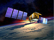 Jason-2 (OSTM)
Jason ist der Name eines gemeinsamen Satellitenprogramms zur Meeresbeobachtung von NASA (USA) und CNES (Frankreich).
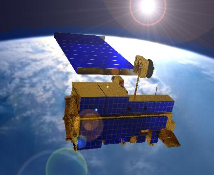
Jason 1, Nachfolger des Satelliten TOPEX/Poseidon, wurde zusammen mit TIMED am 7. Dezember 2001 mit einer Delta-7920-Trägerrakete von der Vandenberg Air Force Base aus gestartet. Er befindet sich auf einer 1340 km hohen zirkularen Umlaufbahn mit einer Bahnneigung von 66,0°.
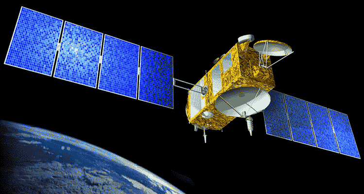
Jason 2, auch OSTM (Ocean Surface Topography Mission) genannt, folgte am 20. Juni 2008. Er wurde ebenfalls von Vandenberg aus auf eine 1340 km hohe zirkulare Kreisbahn mit 66° Bahnneigung gebracht.[1] Der Satellit ist mit dem Zwei-Frequenz-Altimeter „Poseidon 3“ zur Bestimmung der Höhe von Meereswellen ausgerüstet.
Jason 3 ist gegenwärtig in der Planung.
Inhaltsverzeichnis
Instrumente
Die Nutzlasten ähneln denen von TOPEX/Poseidon:
- Poseidon: Höhenmessradar im C-Band und Ku-Band
- Jason microwave radiometer (JMR): Bestimmung des Wasserdampfs zur Korrektur der Höhenradardaten von Poseidon.
- Doppler Orbitography and Radiopositioning Integrated by Satellite (DORIS): Positionsbestimmung und Korrekturdaten für Poseidon
- BlackJack: GPS-Empfänger für Positionsbestimmung
- Laser-Retroreflektor: Bodengestützte Positionsbestimmung
Missionsaufgaben
Zusammen mit dem RA-2 Altimeter auf dem ESA Satelliten Envisat ist Jason die wichtigste Informationsquelle für präzise globale Vorhersagen über Meeresströmungen und Wellengang. Jason wurde besonders für die Beobachtung der tropischen Meere optimiert während andere Altimeter auch mittlere Breiten und die Polargebiete (CryoSat) abdecken. Da Altimeter nur entlang einer relativen schmalen Bodenspur messen können ist es von Vorteil Höheninformationen von mehreren Instrumenten kombinieren zu können.
Besondere Ziele von Jason sind:
- Vermessen des Meeresspiegels mit einer Genauigkeit von besser als 4 cm
- Beobachtung von Meeresströmungen, Wellenhöhenbestimmung und Bestimmung der Windgeschwindigkeiten
- Vorhersage von El Niños
- Gemeinsame Vermessungsaufgaben mit TOPEX/Poseidion bis zu seinem Ausfall Ende 2005
Technische Daten
Die Satelliten basieren auf Alcatels Proteus Satellitenbus. Sie sind per magnetic torque rods (elektromagnetische Ausrichtung am Erdmagnetfeld durch Bordeigene Spulen[2]) dreiachsenstabilisiert und verfügen über ein Antriebssystem mit einem Treibstoffvorrat von 28 kg Hydrazin. Sie sind etwa 500 kg schwer, 3m hoch[3] und sind mit zwei Solarzellenflächen ausgerüstet, welche 0,5 kW (Jason-2) bzw. 1,0 kW Leistung liefern.[4] Die Daten gesammelten werden über ein S-Band Telemetriesystem mit 613 (Jason-1[5]) bzw. 838,86 kbits/s (Jason-2) zur Erde übertragen.[6]
Weblinks
Quellen
- ↑ Jason-2 auf Gunthers Space Page
- ↑ Erklärung für den Satelliten GRAVITY PROBE B
- ↑ BBC Bericht
- ↑ Jason auf Astronautix
- ↑ Jason-1 Fact Sheet der NASA
- ↑ JASON-2 satellite bei der CNS
 Zum Forschungsprogramm Earth Observing System (EOS) der NASA gehörende Missionen
SeaWiFS · TRMM · Landsat 7 · QuikSCAT · Terra · ACRIMSat · NMP/EO-1 · Jason-1 · Sage III · GRACE · Aqua · ADEOS II/Midori II · ICESat · SORCE · Aura · CloudSat · CALIPSO · OCO · Glory · OSTM · Aquarius · NPP · ESSP · NMP/EO-3

Wikimedia Foundation.