Orroroo Carrieton District Council
- Orroroo Carrieton District Council
-
| District Council of Orroroo Carrieton |
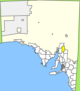
Lage des Orroroo Carrieton District Council in South Australia |
| Gliederung |
| Staat: |
 Australien Australien |
| Bundesstaat: |
 South Australia South Australia |
| Verwaltungssitz: |
Orroroo |
| Daten und Zahlen |
| Einwohner: |
935 (2006) [1] |
|
|
-32.734166666667138.61361111111
Der District Council of Orroroo Carrieton ist ein lokales Verwaltungsgebiet (LGA) im australischen Bundesstaat South Australia. Das Gebiet hat etwa 970 Einwohner.
Orroroo Carrieton liegt in der Northern Region etwa 240 km nördlich der Metropole Adelaide. Das Gebiet beinhaltet 20 Ortsteile und Ortschaften. Der Verwaltungssitz des Councils befindet sich in Orroroo im Süden der LGA.
Verwaltung
Der Council von Orroroo Carrieton hat neun Mitglieder, die acht Councillor und der Vorsitzende (Chairman) des Councils werden von den Bewohnern der LGA gewählt. Der Orroroo Carrieton District Council ist nicht in Bezirke untergliedert.
Weblinks
Einzelnachweise
- ↑ Australian Bureau of Statistics (25. Oktober 2007): Orroroo/Carrieton (DC) (Local Government Area) (Englisch). 2006 Census QuickStats. Abgerufen am 6. April 2010.
Kategorie:
- Local Government Area in South Australia
Wikimedia Foundation.
Schlagen Sie auch in anderen Wörterbüchern nach:
District Council of Orroroo Carrieton — South Australia Location of District Council of Orroroo Carrieton Popu … Wikipedia
District Council of Mount Remarkable — South Australia Location of the District Council of Mount Remarkable Population … Wikipedia
Orroroo, South Australia — Orroroo South Australia The main street of Orroroo … Wikipedia
Northern Areas Council — South Australia Location of the Northern Areas Council Population … Wikipedia
Carrieton, South Australia — Infobox Australian Place | type = town name = Carrieton state = South Australia caption = lga = postcode = 5432 [ [http://www1.auspost.com.au/postcodes/index.asp?Locality=carrieton sub=1 State=SA Postcode= submit1=Search Carrieton Postcode]… … Wikipedia
Flinders Ranges Council — Infobox Australian Place | type = lga name = Flinders Ranges Council state = sa caption = Location of the Flinders Ranges Council pop = area = 4198 est = seat = mayor = Maxwell McHugh region = logosize = url =… … Wikipedia
Outback Areas Community Development Trust — Outback Areas CDT South Australia Location in South Australia (white) Population … Wikipedia
Local Government Areas of South Australia — This is a list of Local Government Areas of South Australia. The list is split into two groups, based on whether the LGA lies inside the Adelaide metropolitan area. In addition to the LGAs, there is also the Outback Areas Community Development… … Wikipedia
Local Government Areas in South Australia — Der Bundesstaat South Australia im Süden des australischen Kontinents Der australische Bundesstaat South Australia ist unterteilt in 68 lokale Verwaltungsgebiete, die Local Government Areas (LGA). Es bestehen drei Klassifikationen von LGA: City… … Deutsch Wikipedia
Peterborough, South Australia — For other uses, see Peterborough (disambiguation). Peterborough, Australia redirects here. For the town in Victoria, Australia, see Peterborough, Victoria. Peterborough South Australia … Wikipedia
