- Palmers Green
-
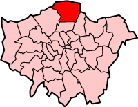
London Borough of Enfield 
Lage in Greater LondonStatus London Borough Region Greater London Verwaltungssitz Enfield Town Fläche 82,20 km² (261.) Einwohner (2007) 285.100 (23.) ONS-Code 00AK Website www.enfield.gov.uk London Borough of Enfield [ˈɛnfiːld] ist ein Stadtbezirk von London. Er ist der am nördlichsten gelegene Stadtbezirk und wurde 1965 bei der Gründung von Greater London aus den Distrikten Enfield, Southgate und Edmonton der Grafschaft Middlesex gebildet. Der Distrikt Potters Bar wurde von Middlesex abgetrennt und gehört nun zur Grafschaft Hertfordshire.
Die deutsche Stadt Gladbeck ist Partnerstadt. Die Filiale der Barclays Bank in Enfield nahm 1967 den weltweit ersten Geldautomaten in Betrieb. Die ethnische Zusammensetzung der Bevölkerung ist wie folgt: 77,1 % Weiße, 7,8 % Südasiaten und 10,5 % Schwarze.
Inhaltsverzeichnis
Stadtteile
- Bowes Park
- Bulls Cross
- Bush Hill Park
- Clay Hill
- Cockfosters
- Crews Hill
- Edmonton
- Enfield Chase
- Enfield Highway
- Enfield Lock
- Enfield Town
- Enfield Wash
- Forty Hill
- Freezywater
- Grange Park
- Hadley Wood
- Lower Edmonton
- New Southgate
- Oakwood
- Palmers Green
- Ponders End
- Southgate
- Upper Edmonton
- Winchmore Hill
Persönlichkeiten
- Harold Abrahams - Leichtathlet und Olympiasieger
- Gladys Aylward - China-Missionarin
- Joseph Bazalgette - bedeutender Tiefbauingenieur
- Michael Garrick - Jazzkeyboarder und Komponist
- Anthony Giddens - Soziologe
- Brian Hart - ehemaliger Rennfahrer und Motorenentwickler
- Brian Harvey - Sänger der Gruppe East 17
- Tony Jarrett - Leichtathlet
- David Jason - Schauspieler
- Ralph Kemplen - Cutter und Regisseur
- Dave Murray - Gitarrist bei Iron Maiden
- Patsy Rowlands - Schauspielerin
- Amy Winehouse - Jazzsängerin
Museen
Bekannte Firmen und Institutionen
- Royal Small Arms Factory - seit 1804 Waffen- und Munitionshersteller
Weblinks
- Enfield Borough Council (Bezirksverwaltung)
- [1] (RSAF und jetzige Nutzung)
Stadtbezirke von LondonBarking and Dagenham | Barnet | Bexley | Brent | Bromley | Camden | City of London | City of Westminster | Croydon | Ealing | Enfield | Greenwich | Hackney | Hammersmith and Fulham | Haringey | Harrow | Havering | Hillingdon | Hounslow | Islington | Kensington and Chelsea | Kingston | Lambeth | Lewisham | Merton | Newham | Redbridge | Richmond | Southwark | Sutton | Tower Hamlets | Waltham Forest | Wandsworth
Sonstige Einteilung: Greater London | Inner London | Outer London | County of London
Wikimedia Foundation.