- Poro (Barangay)
-
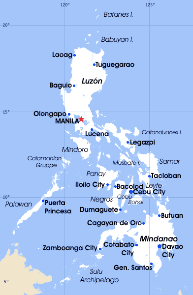
Municipality of Canaman Lage von Canaman in der Provinz Camarines Sur 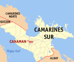
Basisdaten Bezirk: Bicol-Region Provinz: Camarines Sur Baranggays: 24 Distrikt: 2. Distrikt von Camarines Sur PSGC: 051710000 Einkommensklasse: 4. Einkommensklasse Haushalte: 5215 Zensus 1. Mai 2000Einwohnerzahl: 31.583 Zensus 1. August 2007Bevölkerungsdichte: 730 Einwohner je km² Fläche: 43,27 km² Koordinaten: 13° 38′ N, 123° 10′ O13.633333333333123.16666666667Koordinaten: 13° 38′ N, 123° 10′ O Bürgermeister: Joel David S. Abante Offizielle Webpräsenz: www.canaman.gov.ph Geographische Lage auf den Philippinen 

Canaman Canaman ist eine philippinische Stadtgemeinde in der Provinz Camarines Sur. Es wird Bikolano, Filipino/Tagalog und Englisch gesprochen.
Die Stadtgemeinde Canaman liegt zentral gelegen in der Provinz Camarines Sur auf der Insel Luzon.Die Stadtgemeinde Canaman grenzt im Norden an die Gemeinde Magarao, im Süden an die Gemeinden Camaligan und Gainza, im Osten an Naga City, im Westen an die Gemeinden Libmanan und Pamplona und im Südwesten an den Bicol-Fluss. Canaman erstreckt vom Norden bis zum Süden auf 6 km, und von Osten nach Westen auf 14 km. Die Stadtgemeinde von Canaman besteht aus 24 Barangays. Neun von ihnen sind städtische Barangays, während die restlichen fünfzehn landwirtschaftliche Barangays sind. Ein großer Teil der Bevölkerung lebt vom Reisanbau.
Der Namen Canaman entspringt dem Wort Kana, das „Baumaterialien“ bedeutet. Es wird lokativ verbunden mit dem Suffix -man damit entsteht dann ein Wort das ein „Platz anzeigt“, in dem es „Baumaterialien“ gibt.
Barangays
Die Stadtgemeinde Canaman ist unterteilt in 24 Barangays:
Barangay Einwohner Haushalte Baras 2.226 431 Del Rosario 3.000 585 Dinaga 1.569 298 Fundado 387 69 Haring 1.983 395 Iquin 752 143 Liñaga 424 80 Mangayawan 1.380 260 Palo 651 105 Pangpang 875 177 Poro 1.339 246 San Augustin 2.095 402 San Francisco 832 167 San Jose Ost 358 66 San Jose West 380 64 San Juan 241 55 San Nicolas 761 129 San Roque 762 135 San Vicente 2.535 476 Sta. Cruz 1.169 234 Sta. Teresita 1.113 191 Sua 802 132 Talidtid 788 139 Tibgao 1.297 236 Weblinks
- Offizielle Homepage von Canaman (englisch)
Quellen
- www.canaman.gov.ph (englisch)
- www.nscb.gov.ph (englisch)
Städte und Stadtgemeinden in der Provinz Camarines SurStädte: Iriga City | Naga City
Stadtgemeinden: Baao | Balatan | Bato | Bombon | Buhi | Bula | Cabusao | Calabanga | Camaligan | Canaman | Caramoan | Del Gallego | Gainza | Garchitorena | Goa | Lagonoy | Libmanan | Lupi | Magarao | Milaor | Minalabac | Nabua | Ocampo | Pamplona | Pasacao | Pili | Presentacion | Ragay | Sagñay | San Fernando | San Jose | Sipocot | Siruma | Tigaon | Tinambac

Wikimedia Foundation.