- Queen Anne’s County
-
 Das Queen Anne's County Courthouse in Centreville
Verwaltung US-Bundesstaat: Maryland Verwaltungssitz: Centreville Adresse des
Verwaltungssitzes:Queen Anne's County Government
107 N. Liberty St.
Centreville, MD 21617Gründung: 1706 Gebildet aus: Talbot County Vorwahl: 001 410 Demographie Einwohner: 47.798 (2010) Bevölkerungsdichte: 47,1 Einwohner/km² Geographie Fläche gesamt: 1.370 km² Wasserfläche: 356 km² Karte 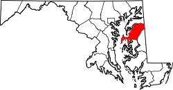
Website: www.qac.org Das Queen Anne’s County[1] ist ein County im US-amerikanischen Bundesstaat Maryland. Bei der Volkszählung im Jahr 2010 hatte das County 47.798 Einwohner und eine Bevölkerungsdichte von 47,1 Einwohnern pro Quadratkilometer. Der Verwaltungssitz (County Seat) ist Centreville.
Inhaltsverzeichnis
Geografie
Das County liegt auf der Delmarva-Halbinsel am östlichen Ufer der Chesapeake Bay und grenzt im Osten an Delaware. Zum Queen Anne’s County gehört Kent Island, die größte Insel in der Chesapeake Bay. Das County hat eine Fläche von 1.370 Quadratkilometern; davon sind 356 Quadratkilometer (26,99 Prozent) Wasserflächen. Es grenzt an folgende Countys:
Kent County Anne Arundel County1 
Kent County
(Delaware)Talbot County Caroline County 1 - Seegrenze in der Chesapeake Bay
Geschichte
 Queen Anne
Das Queen Anne’s County wurde 1706 aus Teilen des Talbot County gebildet.
Benannt wurde es nach Anne Stuart (1665-1714), Königin von England (1702-1714).
1773 wurde ein Teil des Queen Anne's County ausgegliedert, um gemeinsam mit einem Teil des Dorchester County das Caroline County zu bilden.
Demografische Daten
Historische Einwohnerzahlen Census Einwohner ± in % 1790 15.463 — 1800 14.857 -4 % 1810 16.648 10 % 1820 14.952 -10 % 1830 14.397 -4 % 1840 12.633 -10 % 1850 14.484 10 % 1860 15.961 10 % 1870 16.171 1 % 1880 19.257 20 % 1890 18.461 -4 % 1900 18.364 -0,5 % 1910 16.839 -8 % 1920 16.001 -5 % 1930 14.571 -9 % 1940 14.476 -0,7 % 1950 14.579 0,7 % 1960 16.569 10 % 1970 18.422 10 % 1980 25.508 40 % 1990 33.953 30 % 2000 40.563 20 % 2010 47.798 20 % vor 1900[2] 1900–1990[3] 2000[4] 2010[5] Nach der Volkszählung im Jahr 2010 lebten im Queen Anne’s County 47.798 Menschen in 17.169 Haushalten. Die Bevölkerungsdichte betrug 47,1 Einwohner pro Quadratkilometer.
Ethnisch betrachtet setzte sich die Bevölkerung zusammen aus 88,7 Prozent Weißen, 6,9 Prozent Afroamerikanern, 0,3 Prozent amerikanischen Ureinwohnern, 1,0 Prozent Asiaten sowie aus anderen ethnischen Gruppen; 1,7 Prozent stammten von zwei oder mehr Ethnien ab. Unabhängig von der ethnischen Zugehörigkeit waren 3,0 Prozent der Bevölkerung spanischer oder lateinamerikanischer Abstammung.
In den 17.169 Haushalten lebten statistisch je 2,68 Personen.
23,5 Prozent der Bevölkerung waren unter 18 Jahre alt, 62,2 Prozent waren zwischen 18 und 64 und 14,3 Prozent waren 65 Jahre oder älter. 50,4 Prozent der Bevölkerung war weiblich.
Das jährliche Durchschnittseinkommen eines Haushalts lag bei 75.146 USD. Das Pro - Kopf - Einkommen betrug 35.870 USD. 7,3 Prozent der Einwohner lebten unterhalb der Armutsgrenze.[6]
Städte und Gemeinden
- Barcley
- Centreville
- Church Hill
- Millington1
- Queen Anne2
- Queenstown
- Sudlersville
- Templeville3
Census-designated places (CDP)
- Chester
- Grasonville
- Kent Narrows
- Kingstown
- Stevensville
- Crumpton
- Dominion
- Ingleside
- Love Point
- Matapeake
- Price
- Romancoke
- Ruthsburg
1 - teilweise im Kent County
2 - teilweise im Talbot County
3 - teilweise im Caroline CountyEinzelnachweise
- ↑ GNIS-ID: 596089. Abgerufen am 22. Februar 2011 (englisch).
- ↑ University of Virginia Library - Historical Census Browser Abgerufen am 10. September 2011
- ↑ United States Census.gov Abgerufen am 10. September 2011
- ↑ U.S. Census Buero - United States Census 2000 für das Queen Anne’s County Abgerufen am 10. September 2011
- ↑ United States Census 2010 Abgerufen am 10. September 2011
- ↑ U.S. Census Buero, State & County QuickFacts - Queen Anne’s County Abgerufen am 10. September 2011
Weblinks
 Commons: Queen Anne's County, Maryland – Sammlung von Bildern, Videos und Audiodateien
- Offizielle Webseite
- U.S. Census Buero, State & County QuickFacts - Queen Anne’s County
- Maryland State Archives - Queen Anne’s County
- Yahoo Bildersuche - Queen Anne’s County
- www.city-data.com - Queen Anne’s County

Liste der Countys in Maryland
Allegany | Anne Arundel | Baltimore City | Baltimore | Calvert | Caroline | Carroll | Cecil | Charles | Dorchester | Frederick | Garrett | Harford | Howard | Kent | Montgomery | Prince George’s | Queen Anne’s | Saint Mary's | Somerset | Talbot | Washington | Wicomico | Worcester
Wikimedia Foundation.
Schlagen Sie auch in anderen Wörterbüchern nach:
Queen Anne's County — Verwaltung US Bundesstaat: Maryland Verwaltungssitz: Centreville Adresse des Verwaltungssitzes: Gründung: 1706 … Deutsch Wikipedia
Queen Anne's County — Admin ASC 2 Code Orig. name Queen Anne s County Country and Admin Code US.MD.035 US … World countries Adminstrative division ASC I-II
Queen Anne's County Public Schools — is a school district in on the Maryland s Eastern Shore and all schools are accredited by the Middle States Association of Colleges and Schools. [ [http://www.qacps.k12.md.us/home/homeFrameset.html Queen Anne s County Public Schools (Official… … Wikipedia
Queen Anne's County, Maryland — Infobox U.S. County county = Queen Anne s County state = Maryland map size = 225 founded year = 1706 seat wl = Centreville | area total sq mi =510 area land sq mi =372 area water sq mi =138 area percentage = 26.99% census yr = 2000 pop = 40563… … Wikipedia
Queen Anne's County High School — Infobox School name = Queen Anne s County High School imagesize = 240px caption = location = streetaddress = 125 Ruthsburg Road region = city = Centreville, MD state = Maryland district = Queen Anne s County Public Schools zipcode = 21617 country … Wikipedia
Queen Anne's County Courthouse — Infobox Historic building name = Queen Anne s County Courthouse caption = map type = latitude = longitude = location = 100 Courthouse Square location town = Centreville location country = United States of America architect = client = Queen Anne s … Wikipedia
National Register of Historic Places listings in Queen Anne's County, Maryland — Location of Queen Anne s County in Maryland This is a list of the National Register of Historic Places listings in Queen Anne s County, Maryland. This is intended to be a complete list of the properties and districts on the National Register of… … Wikipedia
Queen Anne — may refer to: NOTOC Reigning monarchs* Anne of Great Britain (1665–1714), Queen of England, Scotland and Ireland; after 1707 Queen of Great Britain * Anna of Russia (1693–1740), better known as Anna Ivanovna, Empress of RussiaQueens consort* Anne … Wikipedia
Queen Anne's — ▪ county, Maryland, United States county, eastern Maryland, U.S., bordered by the Chester River to the north, Delaware to the east, and Chesapeake Bay to the west. It consists of a coastal lowland and includes Kent Island, which is linked… … Universalium
Anne Arundel County Public Schools — is the public school district serving Anne Arundel County, Maryland. The AACPS school system is the 5th largest in Maryland,[citation needed] and the 46th largest in the United States.[citation needed] The district has over 5,000 teachers… … Wikipedia
Queen Anne’s County


18+
© Academic, 2000-2024
- Kontaktieren Sie uns: Unterstützung, Werbung
Wörterbücher Export, schritte mit PHP, Joomla, Drupal, WordPress, MODx.