- Richmond-Petersburg Turnpike
-

Basisdaten Länge: 1927 mi/3101 km Bundesstaaten: Florida
Georgia
South Carolina
North Carolina
Virginia
Maryland
Delaware
Pennsylvania
New Jersey
New York
Connecticut
Rhode Island
New Hampshire
Massachusetts
MaineKarte 
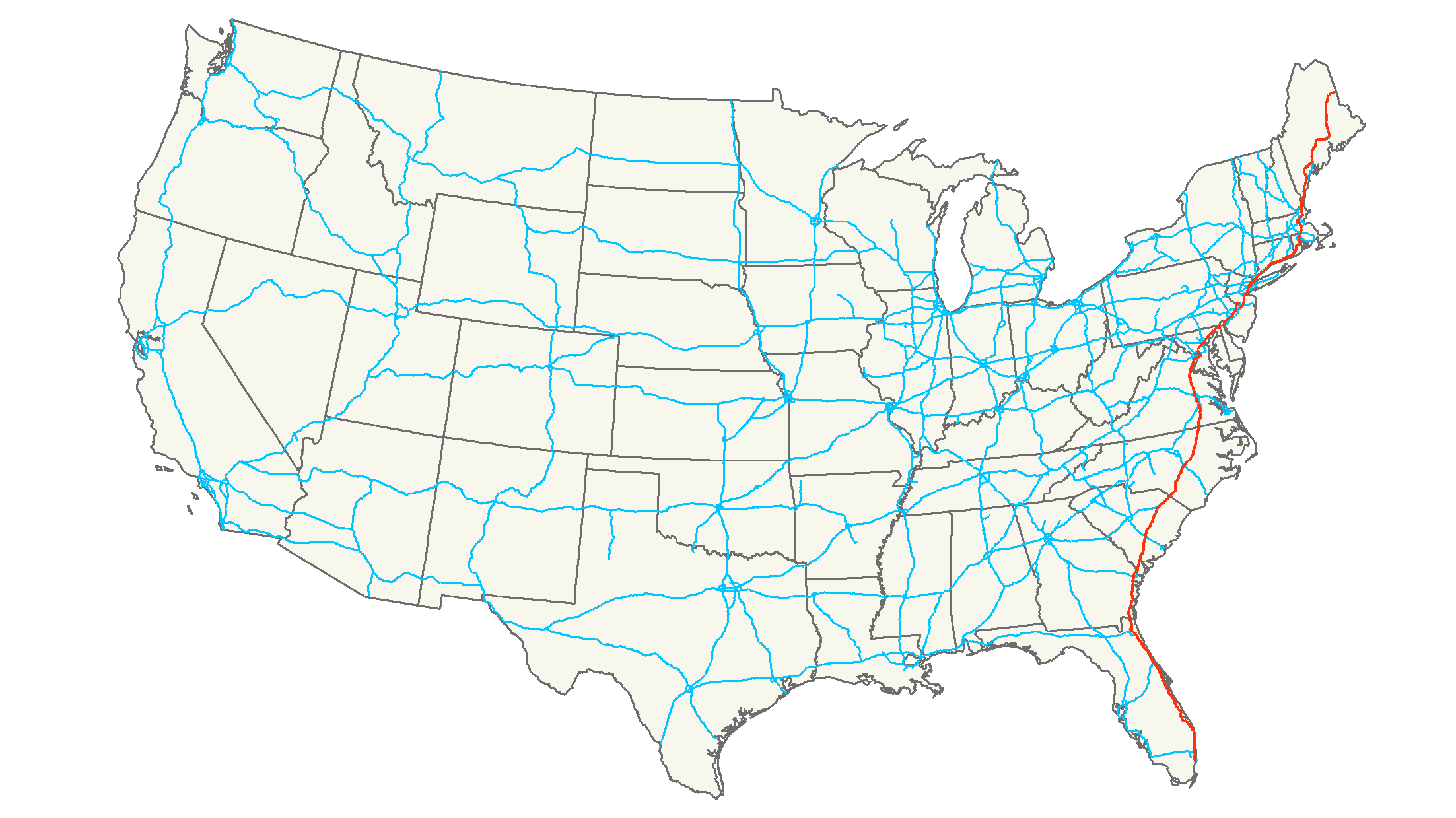
Die Interstate 95 (kurz I-95) ist ein Interstate Highway, der von Miami im südlichen Teil Floridas entlang der gesamten Ostküste der USA bis nach Houlton in Maine nahe der kanadischen Grenze auf einer Länge von 3101 Kilometern verläuft. Dabei führt er durch 15 Bundesstaaten sowie durch die Hauptstadt Washington D. C.. Die größte Teilstrecke führt mit einer Länge von etwa 615 Kilometern durch Florida. Er verbindet einige der größten Städte der USA und ist damit die wichtigste Verkehrsader für den motorisierten Individualverkehr der US-Ostküste.
Inhaltsverzeichnis
Längen
Meilen km Staat 382.17 615.04 Florida 112.03 180.29 Georgia 198.76 319.87 South Carolina 181.71 292.43 North Carolina 178.73 287.64 Virginia 109.05 175.50 Maryland 23.43 37.71 Delaware 51.08 82.21 Pennsylvania 97.76 157.33 New Jersey 23.50 37.82 New York 111.57 179.55 Connecticut 43.3 69.7 Rhode Island 91.95 147.98 Massachusetts 16.20 26.08 New Hampshire 305 491 Maine 1927 3101 Total Größere Städte
Von Norden nach Süden:
- Portland, Maine
- Boston, Massachusetts
- Providence, Rhode Island
- New Haven, Connecticut
- New York City, New York
- Newark, New Jersey
- Philadelphia, Pennsylvania
- Baltimore, Maryland
- Washington (D.C.), District of Columbia
- Richmond, Virginia
- Fayetteville, North Carolina
- Florence, South Carolina
- Savannah, Georgia
- Jacksonville, Florida
- Fort Lauderdale, Florida
- Miami, Florida
Besonderheiten
Unmittelbar vor Überquerung der Grenze zwischen North Carolina und South Carolina befindet sich entlang des I-95 die Touristenattraktion „South of the Border“ (dt.: südlich der Grenze). Hier entstand im Laufe der Zeit eine Ansammlung von Restaurants, Feuerwerkslagern, ein kleiner Rummelplatz und ein Aussichtsturm. Die Werbetafeln, die sogenannten Billboards, für „South of the Border“, welches Mexiko (eben südlich der Grenze) als Gestaltungsthema hat, erstreckt sich fast entlang des gesamten Weges des I-95, also von Florida bis nach New Jersey. Hier sticht die Galionsfigur heraus: Pedro, der fast auf allen „Billboards“ erscheint.
Zubringer und Umgehungen
- Interstate 195 und 395 bei Miami
- Interstate 295 bei Jacksonville
- Interstate 595 bei Port Everglades
- Interstate 295 bei Fayetteville geplant
- Interstate 795 bei Goldsboro
- Interstate 195 und 295 bei Richmond
- Interstate 295, 395, 495 und 695 bei Washington D. C.
- Interstate 195 am Baltimore-Washington International Airport
- Interstate 395, 695, 795 und 895 bei Baltimore
- Interstate 595 bei Annapolis
- Interstate 295 zwischen New Castle und Lawrence Township
- Interstate 495 bei Wilmington
- Interstate 195 bei Jersey Store
- Interstate 295, 695 und 895 bei New York City
- Interstate 495 bei Long Island
- Interstate 395 bei Worcester
- Interstate 195 zur I-495
- Interstate 295 bei Providence
- Interstate 495 bei Bosten
- Interstate 195 bei Old Orchard Beach
- Interstate 295 bei Portland
- Interstate 395 bei Bangor
- Interstate 495 bei Falmouth
Weblinks
- Interstate-Guide (englisch)

Interstate 4 | 5 | 8 | 10 | 12 | 15 | 16 | 17 | 19 | 20 | 22 | 24 | 25 | 26 | 27 | 29 | 30 | 35 | 37 | 39 | 40 | 43 | 44 | 45 | 49 | 55 | 57 | 59 | 64 | 65 | 66 | 68 | 69 | 70 | 71 | 72 | 73 | 74 | 75 | 76 (West) | 76 (Ost) | 77 | 78 | 79 | 80 | 81 | 82 | 83 | 84 (West) | 84 (Ost) | 85 | 86 (West) | 86 (Ost) | 87 | 88 (West) | 88 (Ost) | 89 | 90 | 91 | 93 | 94 | 95 | 96 | 97 | 99 | 238
Hawaii: H-1 | H-2 | H-3 Alaska: A-1 | A-2 | A-3 | A-4 Puerto Rico PR-1 | PR-2 | PR-3

Wikimedia Foundation.