Rocher Thomasset — Motu Nao Motu Nao Géographie Pays France Archipel Îles Marquises Localisation Océan Pacifique … Wikipédia en Français
Motu Nao — Géographie Pays France Archipel Îles Marquises Localisation Océan P … Wikipédia en Français
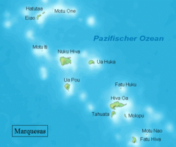
Motu Nao — is the Marquesan name for a small rock island in the southeastern Marquesas Islands, approximately 22 km (14 mi) northeast of Fatu Hiva. The French name for the island is Rocher Thomasset, which in English is Thomasset Rock. At low tide … Wikipedia
Marquesas Islands names — The Marquesas Islands were the first of the island groups discovered by European [[List of explorerin the Pacific. Over the centuries, these Polynesian islands have been variously known by a number of names. The islands are known in Marquesan… … Wikipedia
Bretonische Inseln — Eine Liste der französischen Inseln. Inhaltsverzeichnis 1 Inseln im offenen Meer 1.1 Europäische Atlantikküste und Ärmelkanal 1.1.1 Normandie 1.1.2 Bretagne 1.1.3 Pays de la Loire … Deutsch Wikipedia
Liste französischer Inseln — Eine Liste der französischen Inseln. Inhaltsverzeichnis 1 Inseln im offenen Meer 1.1 Europäische Atlantikküste und Ärmelkanal 1.1.1 Normandie 1.1.2 Bretagne … Deutsch Wikipedia
Motu Nao — Vorlage:Infobox Insel/Wartung/Bild fehlt Motu Nao Gewässer Pazifischer Ozean Inselgruppe Marquesas Geographische Lage … Deutsch Wikipedia
Motu Nao — Motu Nao, o Motuna‘o es el nombre marquesano de una isla rocosa que se encuentra en el sudeste de las islas Marquesas, 22 km al noreste de Fatu Hiva, de quien depende administrativamente. Sus coordenadas son 10.37° S 138.4° O. Su nombre … Wikipedia Español
Список островов Французской Полинезии — Французская Полинезия состоит из 118 островов и атоллов, расположенных в Тихом океане, 67 из них заселены. Общая площадь суши 3660 км² (без площади водной поверхности). Численность населения 259 596 человек[1] [2](2007). Ниже приведён список… … Википедия
Моту-Нао — фр. Motu Nao Координаты: Координаты … Википедия