Ryugasaki

Ryugasaki
龍ケ崎市
Ryūgasaki-shi
Ryūgasaki (Japan)
DEC
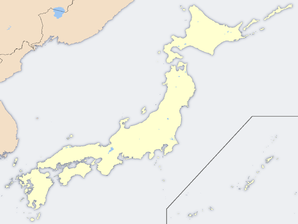
Geographische Lage in Japan
Region: Kantō
Präfektur: Ibaraki
Koordinaten: 35° 55′ N, 140° 11′ O35.911619444444140.182269444447Koordinaten: 35° 54′ 42″ N, 140° 10′ 56″ O
Basisdaten
Fläche: 78,19 km²
Einwohner: 79.187
(1. Feb. 2007)
Bevölkerungsdichte: 1.013 Einwohner je km²
Gemeindeschlüssel: 08208-2
Symbole
Baum: Kiefer
Blume: Ballonblume
Vogel: Schwan
Rathaus
Adresse: Ryūgasaki City Hall
3710
Ryūgasaki-shi
Ibaraki 301-8611
Webadresse:
Lage Ryūgasakis in der Präfektur Ibaraki
Lage Ryūgasakis in der Präfektur

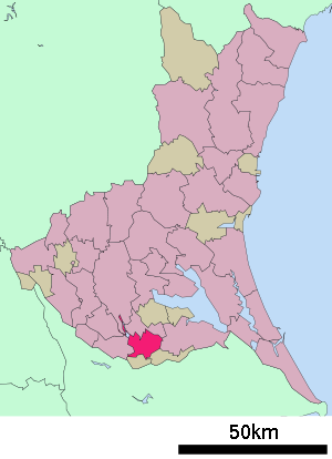
Ryūgasaki (jap. 龍ケ崎市, -shi) ist eine Stadt in der Präfektur Ibaraki in Japan.

Inhaltsverzeichnis

Geographie

Ryūgasaki liegt südlich von Tsuchiura.

Geschichte

Die Stadt wurde am 20. März 1954 gegründet.

Verkehr

  • Straße:
  • Zug:
    • JR Joban-Linie
    • Kantō Tetsudō

Angrenzende Städte und Gemeinden

Weblinks


Wikimedia Foundation.

Игры ⚽ Нужно сделать НИР?

Schlagen Sie auch in anderen Wörterbüchern nach:

  • Ryūgasaki — shi 龍ケ崎市 …   Deutsch Wikipedia

  • Ryugasaki — Original name in latin Rygasaki Name in other language Ryugasaki, Rygasaki State code JP Continent/City Asia/Tokyo longitude 35.9 latitude 140.18333 altitude 8 Population 85761 Date 2012 01 19 …   Cities with a population over 1000 database

  • Ryūgasaki, Ibaraki — nihongo|Ryūgasaki|龍ヶ崎市|Ryūgasaki shi is a city located in Ibaraki, Japan.OverviewAs of 2007, the city has an estimated population of 79,112. The total area is 78.19 km².Ryugasaki is sometimes considered part of the Greater Tokyo Area. Many… …   Wikipedia

  • Ryūgasaki Line — The Ryūgasaki Line is a rail line consisting of only three stations which connects the JR East Jōban Line at Sanuki with the city of Ryūgasaki, Ibaraki. The station between the two is Ireji. The Ryūgasaki Line is, along with the Joso Line, a part …   Wikipedia

  • Ryugasaki-shi — Admin ASC 2 Code Orig. name Ryūgasaki shi Country and Admin Code JP.14.2111256 JP …   World countries Adminstrative division ASC I-II

  • Siege of Ryūgasaki — Infobox Military Conflict conflict=Siege of Ryūgasaki partof=the Sengoku period caption= date=1545 place=Ryūgasaki, Shinano Province, near Lake Suwa result=Takeda victory combatant1=Forces loyal to Tozawa Yorichika combatant2=Takeda family forces …   Wikipedia

  • New Central Airlines — New Central Air Service IATA ICAO CUK Callsign CHUOH AIR Founded December 15, 1978 Hubs Chofu Airport …   Wikipedia

  • JP-08 — Karte Basisdaten Verwaltungssitz: Mito Region: Kantō …   Deutsch Wikipedia

  • Kitasōma District, Ibaraki — Kitasōma (北相馬郡; gun) is a district located in Ibaraki, Japan.As of March 1, 2005, the district has a population of 18,734. The total area is 24.90km².Currently, the district has only one town left. *ToneTimeline*July 22, 1878 The district was… …   Wikipedia

  • Sanuki Station — is a train station located in Ryūgasaki, IbarakiLines*East Japan Railway Company (JR East) ** Jōban Line * Kanto Railway ** Ryūgasaki LineLayoutPlatformsJōban Line ###@@@KEYEND@@@###Ryūgasaki Line ###@@@KEYEND@@@###HistoryAdjacent… …   Wikipedia

Share the article and excerpts

Direct link
Do a right-click on the link above
and select “Copy Link”