Sahara Creek

Sahara Creek
Tanbi Wetland Complex
Tanbi Wetland Complex (Gambia)
DEC
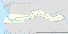
Lage: GBA, Gambia
Besonderheit: Mangrovenwald
Nächste Stadt: Banjul
Fläche: 4500 ha
Gründung: 2001
Besucher: öffentlich 
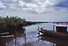
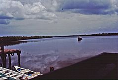
Tanbi Wetland Complex in der Nähe der Lamin Lodge
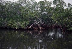
Mangrovenwald
Mangrovenwald
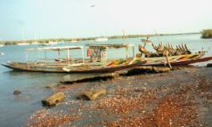
Piroge am Oyster Creek

Der Tanbi Wetland Complex ist ein ausgedehntes Naturschutzgebiet eines Mangrovenwaldes im westafrikanischen Staat Gambia.

Inhaltsverzeichnis

Geographie

Der 4500 Hektar, nach anderer Quelle 6000 ha große Tanbi Wetland Complex liegt westlich der Mündung des Gambia-Flusses in den Atlantischen Ozean. Nordwestlich ist das Gebiet durch die Insel St. Mary’s Island begrenzt, auf der sich die Hauptstadt Banjul befindet. Die Insel wird durch den Kanal Oyster Creek getrennt. Über diesen Kanal führt die Denton Bridge zum Festland in ost-westlicher Richtung. Im Westen liegt Gambias größte Stadt Serekunda, weiter südlich schließen sich die Orte Abuko und Lamin an.

In seinem dichten Kanalnetz fließen einige Nebenflüsse des Gambia wie der Lamin Bolong und der Daranka Bolong, die sich zum Lamin-Daranka-Channel vereinigen. Weiter sind dort zu nennen der Mandinari Bolong, Cape Creek, Parkers Creek, Turnbull Bolong und der Chitabong Bolong.

Namentlich aufgezeichnete Inseln in diesem Gebiet sind Chitabong Island, Daranka Island und Lamin Island.

Das ganze Gebiet steht unter dem Einfluss von Salzwasser – der so genannten Brackwasserzone, es finden sich zahlreiche verschlungene Mangroven. Zahlreiche Sumpf- und Wasservögel lassen sich hier beobachten.

Siehe auch

Literatur

  • Jojo Cobbinah: Senegal, Gambia: praktischer Reiseführer an die Westküste Afrikas. Meyer, Frankfurt am Main 2001, ISBN 3-89859-103-4
  • Ilona Hupe: Gambia. Kleines Urlaubsparadies in Westafrika. Hupe Ilona Verlag, 1999, ISBN 3-932084-19-5
  • Rosel Jahn: Gambia: Reiseführer mit Landeskunde; mit einem Reiseatlas. Mai, Dreieich 1997, ISBN 3-87936-239-4

Weblinks

13.416666666667-16.6166666666677Koordinaten: 13° 25′ 0″ N, 16° 37′ 0″ W


Wikimedia Foundation.

Игры ⚽ Поможем написать реферат

Schlagen Sie auch in anderen Wörterbüchern nach:

  • Sahara — For other uses, see Sahara (disambiguation). Coordinates: Sahara (الصحراء الكبرى) Desert …   Wikipedia

  • McGee Creek State Park — is a state park in southern Oklahoma. The park is on the south side of McGee Creek Reservoir. Created in 1985 the reservoir provides flood control. The park is approximately 2,600 acres (11 km2) and the reservoir is approximately 3,800 acres …   Wikipedia

  • Darr River — Darr RiverVorlage:Infobox Fluss/GKZ fehlt Lage Queensland (Australien) Flusssystem Cooper Creek Abfluss über Thomson River → Cooper Creek → Lake Eyr …   Deutsch Wikipedia

  • Liste der Gewässer in Gambia — Die Liste der Gewässer in Gambia ist eine Aufstellung von Gewässern im westafrikanischen Staat Gambia. Inhaltsverzeichnis 1 Fließgewässer 1.1 Fließgewässer, die im Atlantik münden 1.2 Flusssystem Gambia …   Deutsch Wikipedia

  • Histoire des mines d'or — Les mines d or ont longtemps mobilisé des millions d orpailleurs, ces chercheurs d or attirés par la moindre rumeur, générant d innombrables conflits et colonisations de territoires, ou même de continents entiers. Une partie seulement des… …   Wikipédia en Français

  • AUSTRALIE — L’Australie est l’un des plus grands États du monde. Sa vaste superficie (7 682 300 km2), presque celle de l’Europe, ne contient néanmoins que 17,4 millions d’habitants (2,2 hab./km2) en 1992. De plus, cette population est très inégalement… …   Encyclopédie Universelle

  • Список телесериалов по наименованию — Содержание 1 Русскоязычные 2 На других языках 3 0 9 4 Латиница …   Википедия

  • List of anarchist communities — This is a list of anarchist communities, past and present.Throughout history, anarchists have been involved in a wide variety of communities. While there are only a few instances of large scale anarchies that have come about from explicitly… …   Wikipedia

  • Nightwish — à Melbourne en 2008 Pays d’origine Kitee …   Wikipédia en Français

  • Meteorite fall — Witnessed Bolide Meteorite falls, also called observed falls, are those meteorites that were witnessed by people or automated devices as they moved through the atmosphere or hit the Earth, and were subsequently collected. All other meteorites are …   Wikipedia

Share the article and excerpts

Direct link
Do a right-click on the link above
and select “Copy Link”