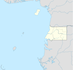
Saint Isabel Airport

Saint Isabel Airport
Malabo International Airport
Flughafen Malabo (Äquatorialguinea)
DEC
Kenndaten
IATA-Code SSG
ICAO-Code FGSL
Koordinaten
Verkehrsanbindung
Entfernung vom Stadtzentrum 9 km östlich von Malabo
Straße
Basisdaten
Eröffnung
Betreiber Aeropuertos De Guinea Ecuatorial (ADGE)
Fläche
Terminals 1
Start- und Landebahn
05/23 2.940 m × 46 m Beton

Der Flughafen Malabo oder Saint Isabel Airport ist der größte Flughafen in Äquatorialguinea. Er liegt auf der Insel Bioko, etwa neun Kilometer westlich der Hauptstadt Malabo. Er wird von der „Aeropuertos De Guinea Ecuatorial (ADGE)“ betrieben.

Allgemein

Der Flughafen wurde früher hauptsächlich von der Regierung Äquatorialguineas genutzt. Während des Biafra-Kriegs wurde der Airport für Flüge nach Biafra in Nigeria verwendet. Mittlerweile hat der Flughafen einen internationalen Status und mehrere europäische Fluglinien fliegen nach Malabo. Der Malabo Airport ist mit dem Flughafen Bata der einzige Flughafen in Äquatorialguinea, der eine befestigte Landebahn besitzt. Außerdem wird der Malabo Airport für militärische Zwecke genutzt. Mehrere Parkpositionen ermöglichen die Ankunft größerer Maschinen wie etwa die eines Airbus A330 oder einer McDonnell Douglas MD-11.

Ziele

Es werden einige Flüge nach Europa von führenden Airlines wie Lufthansa, KLM Royal Dutch Airlines oder Air France angeboten. Flüge innerhalb Afrikas wie etwa nach Kamerun stehen auf dem Flugplan. Außerdem werden Frachtflüge von zwei Frachtfluggesellschaften durchgeführt.

Weblinks


Wikimedia Foundation.

Игры ⚽ Нужно решить контрольную?

Schlagen Sie auch in anderen Wörterbüchern nach:

  • Isabel Martínez de Perón — María Estela Martínez de Perón 42nd President of Argentina In office 29 June 1974 24 March 1976 interim until 1 July Preceded by …   Wikipedia

  • Malabo International Airport — Malabo International Airport, June 2007 IATA: SSG – ICAO: FGSL …   Wikipedia

  • Effects of Hurricane Isabel in Maryland and Washington, D.C. — Infobox Hurricane Impact Name=Hurricane Isabel Type=Tropical storm Year=2003 Basin=Atl Image location=Hurricane Isabel flood damage Maryland.jpg Bowleys Quarters, Maryland Date=September 19, 2003 1 min winds=50 Gusts= Da Fatalities=1 direct Areas …   Wikipedia

  • Effects of Hurricane Isabel in Canada — Infobox Hurricane Impact Name=Hurricane Isabel Type=Extratropical cyclone Year=2003 Basin=Atl Image location=Hurricane Isabel (Canada).jpg Date=September 19, 2003 1 min winds=30 Gusts= Da Fatalities=1 indirect Areas=Canada Rainfall= Hurricane… …   Wikipedia

  • Gregorio Luperón International Airport — Aeropuerto Internacional Gregorio Luperón IATA: POP – ICAO: MDPP …   Wikipedia

  • Air France destinations — This is a list of destinations that Air France flies to, including Air France Cargo services and those destinations served by franchisees Airlinair, Brit Air, CityJet, CCM Airlines and Régional.AfricaCentral Africa*Angola **Luanda (Quatro de… …   Wikipedia

  • Lufthansa destinations — This is a list of cities, with associated airports, that Lufthansa flies to. It includes destinations served by subsidiaries Lufthansa CityLine and Lufthansa Regional as well as serviced operated on behalf of Lufthansa by PrivatAir.For freighter… …   Wikipedia

  • Liste Des Codes OACI Des Aéroports/F — A B C D E F G H I J K L M N O P Q R S T U V W X Y Z Format des données : Code OACI (code AITA) – Nom de l aérodrome – Ville desservie (département) – Altitude aérodrome – Nombre de …   Wikipédia en Français

  • Liste des codes OACI des aeroports/F — Liste des codes OACI des aéroports/F A B C D E F G H I J K L M N O P Q R S T U V W X Y Z Format des données : Code OACI (code AITA) – Nom de l aérodrome – Ville desservie (département) – Altitude aérodrome – Nombre de …   Wikipédia en Français

  • Liste des codes OACI des aéroports/F — A B C D E F G H I J K L M N O P Q R S T U V W X Y Z Format des données : Code OACI (code AITA) – Nom de l aérodrome – Ville desservie (département) – Altitude aérodrome – Nombre de …   Wikipédia en Français

Share the article and excerpts

Direct link
Do a right-click on the link above
and select “Copy Link”