- Somerset County (Pennsylvania)
-
Verwaltung US-Bundesstaat: Pennsylvania Verwaltungssitz: Somerset Adresse des
Verwaltungssitzes:Somerset County Government
300 North Center Avenue
Somerset, PA 15501Gründung: 17. April 1795 Gebildet aus: Bedford County Vorwahl: 001 814 Demographie Einwohner: 80.023 (2000) Bevölkerungsdichte: 28,8 Einwohner/km² Geographie Fläche gesamt: 2.800 km² Wasserfläche: 17 km² Karte 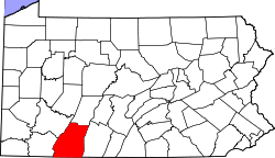
Website: www.co.somerset.pa.us Somerset County[1] ist ein County im US-Bundesstaat Pennsylvania der Vereinigten Staaten von Amerika. Bei der Volkszählung im Jahr 2000 hatte das County 80.023 Einwohner und eine Bevölkerungsdichte von 29 Einwohnern pro Quadratkilometer. Der Verwaltungssitz (County Seat) ist Somerset.
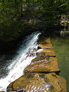 Der Jones Mill Run Dam im Laurel Hill State Park
Inhaltsverzeichnis
Geografie
Das County hat eine Fläche von 2800 Quadratkilometern, wovon 17 Quadratkilometer Wasserfläche sind.
Städte und Ortschaften
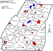 Karte des Somerset Countys
- Addison Township
- Addison
- Allegheny Township
- Benson
- Berlin
- Black Township
- Boswell
- Brothersvalley Township
- Callimont
- Casselman
- Central City
- Conemaugh Township
- Confluence
- Davidsville
- Elk Lick Township
- Fairhope Township
- Friedens
- Garrett
- Greenville Township
- Hooversville
- Indian Lake
- Jefferson Township
- Jenner Township
- Jennerstown
- Jerome
- Larimer Township
- Lincoln Township
- Lower Turkeyfoot Township
- Meyersdale
- Middlecreek Township
- Milford Township
- New Baltimore
- New Centerville
- Northampton Township
- Ogle Township
- Paint Township
- Paint
- Quemahoning Township
- Rockwood
- Salisbury
- Shade Township
- Shanksville
- Somerset Township
- Somerset
- Southampton Township
- Stonycreek Township
- Stoystown
- Summit Township
- Upper Turkeyfoot Township
- Ursina
- Wellersburg
- Windber
Historische Einwohnerzahlen Census Einwohner ± in % 1900 49.461 — 1910 67.717 40 % 1920 82.112 20 % 1930 80.764 -2 % 1940 84.957 5 % 1950 81.813 -4 % 1960 77.450 -5 % 1970 76.037 -2 % 1980 81.243 7 % 1990 78.218 -4 % 2000 80.023 2 % 1900–1990[2] 2000[3]
Einzelnachweise
- ↑ Somerset County im Geographic Names Information System des United States Geological Survey. Abgerufen am 22. Februar 2011
- ↑ Auszug aus Census.gov. Abgerufen am 28. Februar 2011
- ↑ Auszug aus factfinder.census.gov Abgerufen am 28. Februar 2011
Weblinks
-
 Commons: Somerset County, Pennsylvania – Sammlung von Bildern, Videos und Audiodateien

Liste der Countys in Pennsylvania
Adams | Allegheny | Armstrong | Beaver | Bedford | Berks | Blair | Bradford | Bucks | Butler | Cambria | Cameron | Carbon | Centre | Chester | Clarion | Clearfield | Clinton | Columbia | Crawford | Cumberland | Dauphin | Delaware | Elk | Erie | Fayette | Forest | Franklin | Fulton | Greene | Huntingdon | Indiana | Jefferson | Juniata | Lackawanna | Lancaster | Lawrence | Lebanon | Lehigh | Luzerne | Lycoming | McKean | Mercer | Mifflin | Monroe | Montgomery | Montour | Northampton | Northumberland | Perry | Philadelphia | Pike | Potter | Schuylkill | Snyder | Somerset | Sullivan | Susquehanna | Tioga | Union | Venango | Warren | Washington | Wayne | Westmoreland | Wyoming | York
Wikimedia Foundation.
Schlagen Sie auch in anderen Wörterbüchern nach:
Somerset Township, Somerset County, Pennsylvania — Infobox Settlement official name = Somerset Township, Somerset County, Pennsylvania settlement type = Township nickname = motto = imagesize = image caption = image mapsize = 250x200px map caption = Map of Somerset County, Pennsylvania… … Wikipedia
Somerset County, Pennsylvania — Infobox U.S. County county = Somerset County state = Pennsylvania map size = 225 founded = April 17, 1795 seat = Somerset | largest city = Somerset area total sq mi =1081 area water sq mi =7 area percentage = 0.60% census yr = 2000 pop = 80023… … Wikipedia
National Register of Historic Places listings in Somerset County, Pennsylvania — Location of Somerset County in Pennsylvania This is a list of the National Register of Historic Places listings in Somerset County, Pennsylvania. This is intended to be a complete list of the properties and districts on National Register of… … Wikipedia
Conemaugh Township, Somerset County, Pennsylvania — For other Pennsylvania townships of the same name, see Conemaugh Township, Pennsylvania (disambiguation). Conemaugh Township, Somerset County, Pennsylvania Township … Wikipedia
Middlecreek Township, Somerset County, Pennsylvania — Not to be confused with Middlecreek Township, Snyder County, Pennsylvania. Middlecreek Township, Somerset County, Pennsylvania Township … Wikipedia
Milford Township, Somerset County, Pennsylvania — For other Pennsylvania townships of the same name, see Milford Township, Pennsylvania. Milford Township, Somerset County, Pennsylvania Township … Wikipedia
Northampton Township, Somerset County, Pennsylvania — Not to be confused with Northampton, Pennsylvania or Northampton Township, Bucks County, Pennsylvania. Northampton Township, Somerset County, Pennsylvania Township … Wikipedia
Ogle Township, Somerset County, Pennsylvania — Township Map of Somerset Count … Wikipedia
Stonycreek Township, Somerset County, Pennsylvania — Infobox Settlement official name = Stonycreek Township, Somerset County, Pennsylvania settlement type = Township nickname = motto = imagesize = image caption = The temporary Flight 93 National Memorial image mapsize = 250x200px map caption = Map… … Wikipedia
Allegheny Township, Somerset County, Pennsylvania — Infobox Settlement official name = Allegheny Township, Somerset County, Pennsylvania settlement type = Township nickname = motto = imagesize = image caption = image mapsize = 250x200px map caption = Map of Somerset County, Pennsylvania… … Wikipedia
Somerset County (Pennsylvania)


18+
© Academic, 2000-2024
- Kontaktieren Sie uns: Unterstützung, Werbung
Wörterbücher Export, schritte mit PHP, Joomla, Drupal, WordPress, MODx.