Saint Mary’s County — Das Saint Mary’s County Courthouse in Leonardtown Verwaltung US Bundesstaat: Maryland … Deutsch Wikipedia
Saint Mary's County — Verwaltung US Bundesstaat: Maryland Verwaltungssitz: Leonardtown Adresse des Verwaltungssitzes: Gründung: 1637 … Deutsch Wikipedia
Saint Mary's County — Admin ASC 2 Code Orig. name Saint Mary s County Country and Admin Code US.MD.037 US … World countries Adminstrative division ASC I-II
St. Mary's County, Maryland — Infobox U.S. County county = Saint Mary s County state = Maryland map size = 225 founded year = 1637 seat wl = Leonardtown | area total sq mi =764 area land sq mi =361 area water sq mi =403 area percentage = 52.8% census yr = 2000 pop = 86211… … Wikipedia
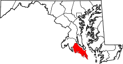
National Register of Historic Places listings in St. Mary's County, Maryland — Location of St. Mary s County in Maryland This is a list of the National Register of Historic Places listings in St. Mary s County, Maryland. This is intended to be a complete list of the properties and districts on the National Register of… … Wikipedia
St. Mary's County Sheriff's Office — The St. Mary s County Sheriff s Office is the primary law enforcement agency servicing St. Mary s County, Maryland. It has a direct jurisdiction of 764 square miles servicing (as of 2000) a population of 86,211 people. [ [http://www.co.saint… … Wikipedia
Oakville, St. Mary's County, Maryland — Oakville is an unincorporated community in St. Mary s County, Maryland, United States.[1] Sandgates On Cat Creek was listed on the National Register of Historic Places in 1978.[2] The area was the scene of the murder of Stephanie Roper.… … Wikipedia
St. Mary's County Public Schools — ( [http://www.smcps.org// SMCPS] ) is a school district that serves St. Mary s County, Maryland, USA, at the confluence of the Potomac River, Patuxent River, and Chesapeake Bay. The area is a mixture of rural and suburban communities. Many of the … Wikipedia
List of St. Mary's County Sheriffs — This is a comprehensive list of individuals that have served as Sheriff of St. Mary s County, Maryland, in chronological order. [http://www.firstsheriff.com/countysheriffs.asp St. Mary s County Sheriff] *Lord William Baldridge 1634 *James… … Wikipedia
Sotterley (St. Mary's County, Maryland) — Infobox nrhp | name =Sotterley nrhp type = nhl caption = nearest city= Hollywood, Maryland lat degrees = 38 lat minutes = 22 lat seconds = 47 lat direction = N long degrees = 76 long minutes = 32 long seconds = 20 long direction = W locmapin =… … Wikipedia

