- Sudurland
-
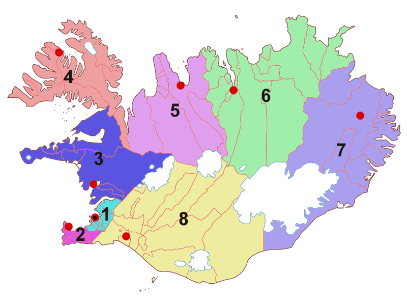
 Die acht Regionen Islands. Suðurland ist Nr. 8 (gelb)
Suðurland ist eine der acht Regionen Islands. Sie liegt im Süden des Landes. Ihr Verwaltungssitz ist Selfoss in der Gemeinde Árborg. Am 1. Dezember 2008 lebten 24.176 Einwohner auf einer Fläche von 24.690 km² (Bevölkerungsdichte: 0,979 Einwohner/km²).
Einteilung in Kreise und kreisfreie Gemeinden
Suðurland gliedert sich in drei Kreise und zwei kreisfreie Gemeinden.
Code-Nr. Kreisfreie Gemeinde Einwohner
(1. Dezember 2007)Fläche
[km²]Verwaltungssitz 8000 Vestmannaeyjabær 4040 17 Vestmannaeyjar 8200 Sveitarfélagið Árborg 7565 158 Selfoss Code-Nr. Kreis Einwohner
(1. Dezember 2007)Fläche [km²] Verwaltungssitz 8500 Vestur-Skaftafellssýsla 954 7.701 Vík í Mýrdal 8600 Rangárvallasýsla 3.459 7.971 Hvolsvöllur 8700 Árnessýsla 7.460 8.287 Selfoss Einteilung in Gemeinden
Suðurland gliedert sich in 14 Gemeinden (Stand (1. Dezember 2007).
Gem.-Nr. Gemeinde Einwohner
(1. Dezember 2007)Fläche
[km²]größere Orte Kreisfreie Gemeinden 8000 Vestmannaeyjabær 4040 17 Heimaey 8200 Sveitarfélagið Árborg 7565 158 Selfoss, Eyrarbakki, Stokkseyri Vestur-Skaftafellssýsla 8508 Mýrdalshreppur 488 755 Vík í Mýrdal 8509 Skaftárhreppur 466 6.946 Kirkjubæjarklaustur Rangárvallasýsla 8610 Ásahreppur 171 2.942 8613 Rangárþing eystra 1741 1.841 Hvolsvöllur, Skógar 8614 Rangárþing ytra 1547 3.188 Hella Árnessýsla 8710 Hrunamannahreppur 794 1.205 8716 Hveragerðisbær 2274 8 Hveragerði 8717 Sveitarfélagið Ölfus 1930 738 Þorlákshöfn 8719 Grímsnes- og Grafningshreppur 379 900 8720 Skeiða- og Gnúpverjahreppur 535 2.402 8721 Bláskógabyggð 972 3.300 Laugarvatn, Skálholt 8722 Flóahreppur 576 290 Weblinks
- www.sudurland.is (isländisch)
 Regionen in Island
Höfuðborgarsvæðið | Suðurnes | Vesturland | Vestfirðir | Norðurland vestra | Norðurland eystra | Austurland | Suðurland
Wikimedia Foundation.