Tararua Ranges

Tararua Ranges

dep1f1dep2p5

Tararua Range
Nordinsel Neuseelands mit Lage der Tararua Range

Nordinsel Neuseelands mit Lage der Tararua Range

Höchster Gipfel Mt. Mitre (1571 m) p2
Lage Nordinsel Neuseeland
Koordinaten 40° 46′ S, 175° 23′ O-40.766666666667175.383333333337Koordinaten: 40° 46′ S, 175° 23′ O


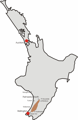
Die Tararua Range oder Tararua Ranges ist ein Gebirgszug im südlichen Bereich der Nordinsel Neuseelands, der zwischen Palmerston North und Upper Hutt auf einer Länge von circa 110 Kilometern parallel zur Küstenlinie verläuft. Der breiteste Bereich des Gebirgsrückens weist etwa 40 Kilometer auf.

An seiner Südspitze geht der Bergkamm in die Rimutaka Range über, die ihrerseits die Ostflanke vom Wellington Harbour bildet. Suedlich von Palmerston North bildet die Ruahine Range die Fortsetzung der Tararua Range, dabei bildet der Manawatu River die natürliche Grenze zwischen den beiden Gebirgszügen.

Die einzige Straße, die über den Gebirgszug führt, verläuft von Palmerston North nach Pahiatua. Die Straße durch die Manawatu Schlucht, der Abschnitt des State Highway 3 zwischen Palmerston North und Woodville ist besonders im Winter sehr behinderungsanfällig, auch die Eisenbahnstrecke von Napier nach Wellington führt hier durch. Im Süden windet sich der State Highway 2 zwischen Upper Hut und Featherston über das Gebirge.

Der Otaki River entspringt in der Tararua Range und passiert den Mount Crawford auf seinem Weg nach Südwesten.

Die höchsten Erhebungen des Gebirges sind

  • Mt. Mitre (1571 m)
  • Mt. Duncas (1500 m)
  • Mt. T. Crowford (1462 m)

Zahlreiche touristisch sehr interessante Gebiete werden besonders von der Kapiti Coast erschlossen, für das nahe Wellington ist der Gebirgszug mit dem Tararua Forest Park ein beliebtes Ziel für Wanderer und Bergsteiger.


Wikimedia Foundation.

Игры ⚽ Поможем сделать НИР

Schlagen Sie auch in anderen Wörterbüchern nach:

  • Tararua Wind Farm — Infobox Power Station station name=Tararua Wind Farm location= Tararua Ranges, New Zealand owner= Trustpower status= fuel type= Wind mine type= conveyance= cooling water= technology= combined cycle= turbines= 134 reciprocating engines= pumped… …   Wikipedia

  • Tararua Range — The Tararua Range (often referred to as the Tararua Ranges ) is one of several mountain ranges in the North Island of New Zealand which form a ridge running parallel with the east coast of the island between East Cape and Wellington.The ridge is… …   Wikipedia

  • Tararua Range — dep1f1dep2p5 Tararua Range Nordinsel Neuseelands mit Lage der Tararua Range Höchster Gipfel …   Deutsch Wikipedia

  • Ruahine Ranges — Die Ruahine Range ist einer von mehreren Gebirgszügen auf der Nordinsel Neuseelands, die parallel zur Ostküste der Insel zwischen East Cape und Wellington verlaufen. Diese Gebirgsrücken ist im Südteil der Insel am ausgeprägtesten, wo er aus der… …   Deutsch Wikipedia

  • Manawatu-Wanganui Region —   Region of New Zealand   Country …   Wikipedia

  • Manawatu-Wanganui — is a region situated in the lower half of the North Island of New Zealand, around the city of Palmerston North and the central city of Wanganui.GeographyAdministrationThe region is comprised by all or parts of ten separate Districts. Five of… …   Wikipedia

  • Palmerston North — Te Papaioea (Māori)   Metropolitan Area   Palmerston North City Council …   Wikipedia

  • Huia — This article is about the extinct bird species. For other uses, see Huia (disambiguation). Huia A pair (male in front of female) Painting by J.G. Keulemans from W.L. Buller s A History of the Birds of New Zealand (1888) …   Wikipedia

  • Woodville, New Zealand — Woodville is a small town in the southern North Island of New Zealand. It is located 75 km north of Masterton and 25 km east of Palmerston North, and has a population of 1,479 (2001 census).Local authoritiesThe town is located in the Tararua… …   Wikipedia

  • Ashhurst — is a small town in the Manawatu Wanganui region of New Zealand s North Island. Location, features and populationAshhurst is sited 14 kilometres northeast of the city of Palmerston North and is a small rural town with a population of 2,526 (2006… …   Wikipedia

Share the article and excerpts

Direct link
Do a right-click on the link above
and select “Copy Link”