- Upper Holloway
-
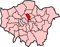
London Borough of Islington 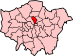
Lage in Greater LondonStatus London Borough Region Greater London Verwaltungssitz Islington Fläche 14,86 km² (352.) Einwohner (2007) 187.800 (74.) ONS-Code 00AU Website www.islington.gov.uk London Borough of Islington [ˈɪzlɪŋtən] ist ein Stadtbezirk von London. Er liegt unmittelbar nördlich der City of London und entstand bei der Gründung von Greater London im Jahr 1965 durch die Zusammenlegung der Bezirke Islington und Finsbury der ehemaligen County of London.
In Islington sind die sozialen Gegensätze sehr hoch. Einerseits leben 55 % der Bevölkerung in Sozialwohnungen, andererseits findet man hier Immobilien, die mehr als 3 Millionen Pfund wert sind. In Islington befinden sich zwei Gefängnisse (Holloway Prison und Pentonville Prison), aber auch das Emirates Stadium des FC Arsenal oder der Theaterkomplex Sadler's Wells. Die Bevölkerung setzt sich folgendermaßen zusammen: 75,4 % Weiße, 11,9 % Schwarze, 5,4 % Südasiaten und 1,7 % Chinesen.
Inhaltsverzeichnis
Stadtteile
- Angel
- Archway
- Barnsbury
- Canonbury
- Clerkenwell
- Finsbury
- Highbury
- Holloway
- Islington
- Kings Cross
- Lower Holloway
- Pentonville
- Tufnell Park
- Upper Holloway
Persönlichkeiten
- Danny Beauchamp - Topmodel
- Jonny Buckland - Gitarrist der Band Coldplay
- Alexandra Burke - Sängerin (Gewinnerin The X Factor (Castingshow) 2008)
- Chris Carter – Musiker
- Dwain Chambers – Leichtathlet
- Terence Mark Coldwell - Popsänger (East 17)
- Joe Cole – Fußballspieler
- Amelia Edwards – Schriftstellerin und Ägyptologin
- Chris Farlowe – R&B-Sänger
- Tony Hadley – Popsänger (Spandau Ballet)
- Sidney Jones - Komponist und Dirigent
- Mary Kingsley – Entdeckerin und Ethnologin
- Ethel Larcombe - Tennisspielerin und Wimbledonsiegerin 1912
- Charles Robert Leslie – Maler
- Leona Lewis - Sängerin
- John Stuart Mill – Philosoph und Ökonom
- Robert Muchamore - Autor der CHERUB-Buchserie
- Dadabhai Naoroji - wurde 1892 im Wahlkreis Finsbury als erster indischstämmiger Abgeordneter ins House of Commons gewählt
- Scott Neal – Schauspieler
- Jackie Pallo – Wrestler
- Alan Parker – Drehbuchautor
- Sidney Thomas – Metallurg
- Emily Watson – Schauspielerin
- Charlie Watts – Schlagzeuger (Rolling Stones)
Siehe auch
Weblinks
Stadtbezirke von LondonBarking and Dagenham | Barnet | Bexley | Brent | Bromley | Camden | City of London | City of Westminster | Croydon | Ealing | Enfield | Greenwich | Hackney | Hammersmith and Fulham | Haringey | Harrow | Havering | Hillingdon | Hounslow | Islington | Kensington and Chelsea | Kingston | Lambeth | Lewisham | Merton | Newham | Redbridge | Richmond | Southwark | Sutton | Tower Hamlets | Waltham Forest | Wandsworth
Sonstige Einteilung: Greater London | Inner London | Outer London | County of London
Wikimedia Foundation.