- Westlothian
-
West Lothian
Lodainn an Iar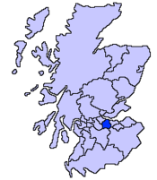
Verwaltungssitz Livingston Fläche 427 km² (20.) Einwohner (2005) 163.780 (10.) ISO 3166-2 GB-WLN ONS-Code 00RH Website www.westlothian.gov.uk West Lothian (traditionell) 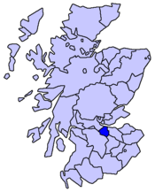
West Lothian [ˌwɛstˈləʊðjən] bzw. Linlithgowshire (gälisch Lodainn an Iar) ist eine von 32 unitary authorities in Schottland. Sie liegt südlich des Firth of Forth und grenzt an Edinburgh, Falkirk und Midlothian.
West Lothian ist auch eine traditionelle Grafschaft. Als solche grenzt sie an Stirlingshire, Lanarkshire und Midlothian.
Inhaltsverzeichnis
Geografie
Der größte Teil des Gebiets ist ein fruchtbares Hügelland; der Südwestteil ist eben, mit ausgedehnten Strecken von Mooren und Heideland. West Lothian ist reich an Eisen, Steinkohlen und Bausteinen.
Orte
- Bathgate
- Broxburn
- Dechmont
- Linlithgow
- Livingston
- Pumpherston
- Stoneyburn
- Uphall
- Whitburn
- Winchburgh
Sehenswürdigkeiten
- Blackness Castle
- Linlithgow Palace
Partnerschaften
Politik
Der Council von West Lothian umfasst 32 Sitze, die sich wie folgt auf die Parteien verteilen:[1]
Partei Sitze Scottish Labour 14 Scottish National Party 13 Action to Save St John's Hospital 3 Scottish Conservatives 1 Unabhängig 1 Quellen
- ↑ West Lothian Council: http://www.westlothian.gov.uk/Council_and_government/pol_elec_democracy/821/ Politics and politicians - council and councillors (Abgerufen am 14.4.2008)

Aberdeen | Aberdeenshire | Angus | Argyll and Bute | Clackmannanshire | Dumfries and Galloway | Dundee | East Ayrshire | East Dunbartonshire | East Lothian | East Renfrewshire | Edinburgh | Falkirk | Fife | Glasgow | Highland | Inverclyde | Midlothian | Moray | Äußere Hebriden | North Ayrshire | North Lanarkshire | Orkney | Perth and Kinross | Renfrewshire | Scottish Borders | Shetland | South Ayrshire | South Lanarkshire | Stirling | West Dunbartonshire | West Lothian
Aberdeenshire | Angus | Argyll | Ayrshire | Banffshire | Berwickshire | Bute | Caithness | Clackmannanshire | Cromartyshire | Dumfriesshire | Dunbartonshire | East Lothian | Fife | Inverness-shire | Lanarkshire | Kincardineshire | Kinross-shire | Kirkcudbrightshire | Mid Lothian | Morayshire | Nairnshire | Orkney | Peeblesshire | Perthshire | Renfrewshire | Ross-shire | Roxburghshire | Selkirkshire | Shetland | Stirlingshire | Sutherland | West Lothian | Wigtownshire


Wikimedia Foundation.