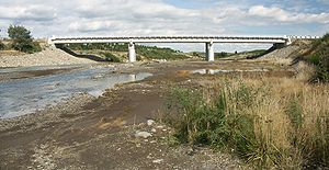
Whangaehu (Fluss) — Brücke über den Whangaehu bei Tangiwai Der Whangaehu River ist einer der großen Flüsse auf der Nordinsel Neuseelands. Er entspringt im Kratersee des Vulkans Ruapehu im Tongariro Nationalpark. Er mündet etwa 13 Kilometer südöstlich von Wanganui… … Deutsch Wikipedia
Whangaehu River — The Whangaehu River is a large river in central North Island of New Zealand. Its headwaters are the crater lake of Mount Ruapehu on the central plateau, and it flows into the Tasman Sea eight kilometres southeast of Wanganui. Length The river… … Wikipedia
Whangaehu River — Brücke über den Whangaehu bei Tangiwai Der Whangaehu River ist einer der großen Flüsse auf der Nordinsel Neuseelands. Er entspringt im Kratersee des Vulkans Ruapehu im Tongariro Nationalpark. Er mündet etwa 13 Kilometer südöstlich von Wanganui… … Deutsch Wikipedia
Mangamahu — … Wikipedia
Tangiwai-Eisenbahnunglück — 39.464166666667175.576666666677Koordinaten: 39° 27′ 51″ S, 175° 34′ 36″ O Das Tangiwai Eisenbahnunglück ( … Deutsch Wikipedia
Tangiwai disaster — 39.464166666667175.576666666677Koordinaten: 39° 27′ 51″ S, 175° 34′ 36″ O Das Tangiwai Eisenbahnunglück ( … Deutsch Wikipedia
Mount Ruapehu — Ruapehu from the Desert Road, 2005 Elevation 2,797 m (9,177 ft) … Wikipedia
Ngāti Apa — Iwi of New Zealand Rohe (location) Manawatu Waka (canoe) Kurahaupō Population 3021 … Wikipedia
New Zealand State Highway 49 — State Highway 49 Route information Maintained by New Zealand Transport Agency Length: 36.2 km (22.5 mi) … Wikipedia
ERLAWS — ERLAWS, the Eastern Ruapehu Lahar Alarm and Warning System, is a lahar warning system installed on Mount Ruapehu following volcanic eruptions in 1995–1996.IntroductionThe 1995–1996 eruptions of Ruapehu in the North Island of New Zealand left a 7… … Wikipedia

