Wokam — Wokam, eine der Aruinseln … Pierer's Universal-Lexikon
Islands of Indonesia — Indonesia comprises 17,508 islands (based from Seminar Nasional Penetapan Nama Pulau pulau Kecil Dalam Presektif Sejarah or National Seminary of Name For Little Islands From History Side , July 16 to 18 at Palembang, South Sumatra, Indonesia, now … Wikipedia
Trangan — Infobox Islands name = Trangan image caption = image size = locator Location map|Indonesia|lat= 6.534941|long=134.348717 map custom = yes native name = native name link = nickname = location = Arafura Sea coordinates =… … Wikipedia
Îles Aru — Pour les articles homonymes, voir Aru (homonymie). Îles Aru Kepulauan Aru (id) … Wikipédia en Français
Islas Aru — Para familia de lenguas, véase Lenguas aimaras. Islas Aru (Kepulauan Aru) Vista de satélite … Wikipedia Español
Tanahbesar — Isla Tanahbesar Pulau Tanahbesar[1] Vista de satélite del grupo de las Aru. Tanahbesar es la más septentrional de las grandes islas del grupo. Loca … Wikipedia Español
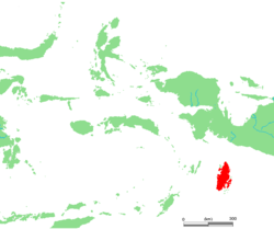
Aru Islands — Location of the Aru Islands among surrounding islands of eastern Indonesia Location of the Ar … Wikipedia
Kobroor — is an island in the Aru Islands in the Arafura Sea. It is situated in the Maluku Province, Indonesia. Its area is 1723 km². The other main islands in the archipelago are Tanahbesar (also called Wokam), Trangan, Kola and Maikoor … Wikipedia
Tanahbesar — (or Wokam) is one of the four main islands in the Aru Islands in the Arafura Sea. Its area is 1604 km².It is situated in the Maluku Province, Indonesia. The other main islands in the archipelago are Kobroor, Kola and Maikoor … Wikipedia
Maikoor — is an island in the Aru Islands in the Arafura Sea. It is situated in the Maluku Province, Indonesia. Its area is 398 km². The other main islands in the archipelago are Kobroor, Tanahbesar (also called Wokam), Trangan and Kola. Coordinates:… … Wikipedia


