- Bicol River
-
Bicol River 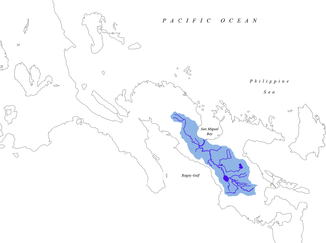
Einzugsgebiet des Bicol Rivers
Daten Lage auf der Insel Luzón Länge 150 km Der Bicol River ist ein Fluss im Bezirk Bicol auf den Philippinen. Er entspringt am Mount Labo und mündet nach ca. 150 km südöstlicher Richtung in die San Miguel Bucht. Er hat ein Wassereinzugsgebiet von 3.770 km², erstreckt sich über drei Provinzen, 38 Municipalitys und drei größere Städte. Der Wasserabfluss beträgt ca. 5.100 Mio. m³ pro Jahr.
Weblinks
Kategorien:- Fluss auf den Philippinen
- Fluss in Asien

Wikimedia Foundation.