Boknafjorden

Boknafjorden
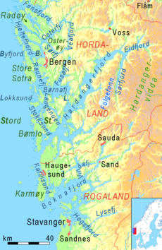
Hardangerfjord und Boknafjord
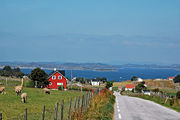
Aussicht von Bokn auf den Boknafjorden
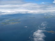
Inselwelt im Boknafjorden

Der Boknafjord ist der größte Fjord der norwegische Fylke Rogaland. Sein Namensgeber ist die an seiner Mündung liegende Insel und Kommune Bokn.

Der Boknafjord erstreckt sich weit ins Inland und wird vor der Nordsee geschützt durch die Halbinsel Tungeneset bei Stavanger und der Insel Karmøy in der Nähe von Haugesund. Der Radius des Fjordes beträgt 20 Kilometer In seinem Innern befindet sich eine umfangreiche Inselwelt, wovon Rennesøy die größte Insel ist. Der bekannteste Abzweig des Fjordes ist der weit nach Osten ragende Lysefjord, mit seinen imponierenden Fjellmassiven Preikestolen und Kjerag.

Von der Nordsee wird er so abgeschirmt, dass seine Ostseite eines der bekanntesten Obstanbaugebiete Norwegens ist. Die zur Zeit des deutschen Kaisers Wilhelm II. eingeführten norddeutschen Obstsorten (Altes Land) werden weiter angebaut.

Bedeutsam ist der Schnellweg Rennfast, der Stavanger und Haugesund durch die Europastraße 39 verbindet, eine beachtliche Ingenieursleistung von unterseeischen Tunneln und Brückenbau, die die früher einsam gelegenen Inseln mit den Ballungszentren Westnorwegens anschließt. Der Fjord und das östliche Fjellmassiv teilte die Fylke Rogaland in Nord- und Südrogaland. So wird diese Landschaft auch heute noch mit den einheitlichen Namen „Ryfylke“ bezeichnet.

Angrenzende oder sich im Fjord befindliche Gemeinden sind Kvitsøy, Rennesøy, Finnøy, Tysvær, Bokn und Karmøy.


Weblinks

59.1666666666675.66666666666677Koordinaten: 59° 10′ 0″ N, 5° 40′ 0″ O


Wikimedia Foundation.

Игры ⚽ Поможем сделать НИР

Schlagen Sie auch in anderen Wörterbüchern nach:

  • Boknafjorden — Sp Bòknafjordenas Ap Boknafjorden L Šiaurės j. įl., Norvegija …   Pasaulio vietovardžiai. Internetinė duomenų bazė

  • Rogaland — Infobox Fylke name = Rogaland idnumber = 11 capital = Stavanger governor = Harald Thune (acting) governor party = governor date = 2008 mayor = Tom Tvedt mayor party = Arbeiderpartiet mayor date = 2007 region = Vestlandet arearank = 13 area = 9378 …   Wikipedia

  • Boknafjord — 59.1666666666675.6666666666667 Koordinaten: 59° 10′ 0″ N, 5° 40′ 0″ O …   Deutsch Wikipedia

  • NO-11 — Wappen Karte Basisdaten Land: Norwegen …   Deutsch Wikipedia

  • Finnøy — Infobox Kommune name = Finnøy idnumber = 1141 county = Rogaland landscape = Ryfylke capital = Judaberg demonym = Finnøying language = Nynorsk munwebpage = www.finnoy.kommune.no governor = Kjell Nes (KrF) governor as of = 2008 arearank = 382 area …   Wikipedia

  • Jæren — is a traditional district stretching across some 65 kilometers on the southwestern coast of Norway. It is located south of Boknafjorden and northwest of Dalane in the county of Rogaland. It has a geographical size of 1,070 km², and the population …   Wikipedia

  • Battle of Nesjar — The Battle of Nesjar was a sea battle off the coast of Norway in 1015 or 1016, in Oslofjord. The exact location is unknown, but it is somewhere in today s Langesundfjorden. The fighting parties were the throne claimant Olav Haraldsson (later… …   Wikipedia

  • List of Norwegian battles — is a list of battles fought in Norway or which a significant number of Norwegians participated.*800 1450 **Battle of Hafrsfjord (ca. 872) **Battle of Solskjel (before 900) **Battle of Rastarkalv (955) **Battle of Fitjar (961) **Battle of… …   Wikipedia

  • Sandsfjord — Sandsfjorden is the outermost part of the northernmost arm of Boknafjorden in Rogaland. The fjord empties into Marvik and opens into Sand where it meets with Sauda and changes its name to Saudafjorden. It is famous for a man once riding down it… …   Wikipedia

  • Rogaland — Wappen Karte Basisdaten Land …   Deutsch Wikipedia

Share the article and excerpts

Direct link
Do a right-click on the link above
and select “Copy Link”