Bridge of Orchy

Bridge of Orchy
Bridge of Orchy
Koordinaten 56° 31′ N, 4° 46′ W56.5175-4.7652777777778Koordinaten: 56° 31′ N, 4° 46′ W
Bridge of Orchy (Schottland)
Bridge of Orchy
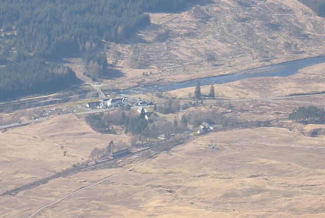
Bridge of Orchy
Verwaltung
Post town BRIDGE OF ORCHY
Postleitzahlen­abschnitt PA36
Vorwahl 01838
Landesteil Scotland
Unitary authority Argyll and Bute
Britisches Parlament Argyll and Bute
Schottisches Parlament Argyll and Bute
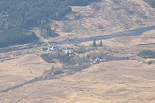
Bridge of Orchy, Blick vom Beinn Dòrain, (900m). Das Hotel und die Brücke sind zu sehen

Bridge of Orchy (schottisch-gälisch: Drochaid Urchaidh) ist ein Ort in der Grafschaft Argyll in Schottland. Der Name des Ortes bezieht sich auf die 1751 von Major Caulfeild erbaute Brücke über den River Orchy.

Gegründet im Jahr 1751, besteht der Ort aus einigen wenigen Häusern rund um ein Touristenhotel. Es ist an der A82 am Kopf des Glen Orchy gelegen, hat eine Eisenbahnstation und liegt am Fernwanderweg West Highland Way.

Seit einigen Jahren entwickelt sich der Ort zur "Geisterstadt". Die Schule ist geschlossen und die Häuser verfallen. Lediglich sieben Einwohner hat Orchy.

Weblinks

 Commons: Bridge of Orchy – Sammlung von Bildern, Videos und Audiodateien

Wikimedia Foundation.

Игры ⚽ Нужно сделать НИР?

Schlagen Sie auch in anderen Wörterbüchern nach:

  • Bridge of Orchy — ( Drochaid Urchaidh in Gaelic) is a landmark hamlet in Argyll, Scotland.Dating back to 1751, it includes a notable tourist hotel. Located at the head of Glen Orchy, it is on the A82 road, has a railway station and is on the West Highland Way long …   Wikipedia

  • Bridge of Orchy railway station — Bridge of Orchy Drochaid Urchaidh …   Wikipedia

  • River Orchy — Orchy Der River Orchy bei der Ortschaft Bridge of OrchyVorlage:Infobox Fluss/KARTE fehlt …   Deutsch Wikipedia

  • Glen Orchy — (Scottish Gaelic: Gleann Urchaidh) is a long glen in Argyll and Bute in Scotland. It runs south westerly from the Bridge of Orchy (gbmapping|NN298392) to Inverlochy (gbmapping|NN194277) following the River Orchy.One of the better known… …   Wikipedia

  • West Highland Way — Infobox Hiking trail Name=West Highland Way Photo=WHW Rannoch Moor.jpg Caption=The sun breaks partially through the clouds in a rainy day on the outskirt of Rannoch Moor in late April 2008 on West Highland Way on the way from Bridge of Orchy to… …   Wikipedia

  • Stob Ghabhar — seen from the south east across Loch Tulla. Elevation …   Wikipedia

  • PA postcode area — Coordinates: 55°45′25″N 4°51′04″W / 55.757°N 4.851°W / 55.757; 4.851 …   Wikipedia

  • Stob a' Choire Odhair — Infobox Mountain Name = Stob a Choire Odhair Photo = Stob a Choire Odhair from the SE.jpg Caption = Stob a Choire Odhair seen from the SE. The slopes of Beinn Toaig are in front with the main summit behind. Elevation = 945 m (3100 ft) Location =… …   Wikipedia

  • Loch Tulla — von Nordwesten Geographische Lage Argyll and Bute, Schottland …   Deutsch Wikipedia

  • Beinn Dorain — Infobox Mountain Name = Beinn Dorain Photo = Beinn Dorain.jpg Caption = Beinn Dorain viewed from the south. Elevation = 1,076 m (3,530 ft) Location = Argyll and Bute, SCO Range = Bridge of Orchy Hills, Grampian Mountains Grid ref UK = NN325378… …   Wikipedia

Share the article and excerpts

Direct link
Do a right-click on the link above
and select “Copy Link”